IMAGES TAKEN NEAR TO
Hall Lane, UPMINSTER, RM14 1UA
Introduction
This page details the photographs taken nearby to Hall Lane, RM14 1UA by members of the Geograph project.
The Geograph project started in 2005 with the aim of publishing, organising and preserving representative images for every square kilometre of Great Britain, Ireland and the Isle of Man.

There are currently over 7.5m images from over14,400 individuals and you can help contribute to the project by visiting https://www.geograph.org.uk
Image Map
Images are licensed for reuse under creativecommons.org/licenses/by-sa/2.0
Notes
- Clicking on the map will re-center to the selected point.
- The higher the marker number, the further away the image location is from the centre of the postcode.
Image Listing (13 Images Found)
Images are licensed for reuse under creativecommons.org/licenses/by-sa/2.0
Image
Details
Distance
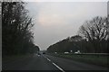
4
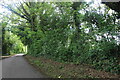
The southern part of Bird Lane
Bird Lane is split into two by the A.127 dual carriageway.
Image: © Robert Edwards
Taken: 11 Feb 2008
0.11 miles
6
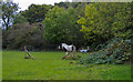
Horse in field near Bird Lane, Cranham
Seen from public footpath.
Image: © Roger Jones
Taken: 18 Oct 2020
0.14 miles
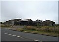
8
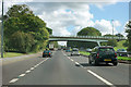
Southend Arterial Road (A127) - Hall Lane Bridge
A state of the art road in the 1930s, but this junction was not grade separated then - in fact none were.
Image: © Robin Webster
Taken: 18 Sep 2011
0.17 miles
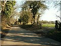
9
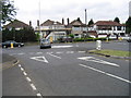
Junction of Hall Lane & Avon Road, Upminster, Essex
Image: © John Winfield
Taken: 16 Jun 2005
0.18 miles
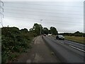
10
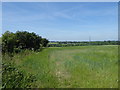
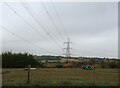
View from Hall Lane and the London LOOP
The London LOOP follows Hall lane between River Drive and the A127 and beyond. If you dodge the traffic there are fine views westwards as here across the valley of the Ingrebourne River near The Strawberry Farm.
Image: © Marathon
Taken: 14 Jun 2017
0.18 miles