IMAGES TAKEN NEAR TO
Severn Drive, UPMINSTER, RM14 1QF
Introduction
This page details the photographs taken nearby to Severn Drive, RM14 1QF by members of the Geograph project.
The Geograph project started in 2005 with the aim of publishing, organising and preserving representative images for every square kilometre of Great Britain, Ireland and the Isle of Man.

There are currently over 7.5m images from over14,400 individuals and you can help contribute to the project by visiting https://www.geograph.org.uk
Image Map
Images are licensed for reuse under creativecommons.org/licenses/by-sa/2.0
Notes
- Clicking on the map will re-center to the selected point.
- The higher the marker number, the further away the image location is from the centre of the postcode.
Image Listing (6 Images Found)
Images are licensed for reuse under creativecommons.org/licenses/by-sa/2.0
Image
Details
Distance

3
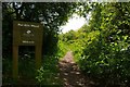
Footpath Through Pot Kiln Wood
This is the footpath that passes through Pot Kiln Wood a little piece of countryside sandwiched between Cranham and the A127, only the noise of tyres on tarmac spoils the peace. The nature reserve is owned by the Woodland Trust http://www.wt-woods.org.uk/potkilnwood
Image: © Glyn Baker
Taken: 5 May 2008
0.22 miles
4
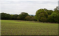
Unmarked footpath over arable land, Cranham
No obvious markings for this public footpath.
Image: © Roger Jones
Taken: 18 Oct 2020
0.22 miles
5
Electricity sub station, Waycross Road
Image: © Alex McGregor
Taken: 14 Aug 2013
0.23 miles
6
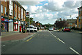
Shops, Avon Road, Cranham
There is a post office here. The bus stop is Front Lane (service 248), which is the intersecting major road ahead.
Image: © Robin Webster
Taken: 18 Sep 2011
0.25 miles