IMAGES TAKEN NEAR TO
Tyne Close, UPMINSTER, RM14 1QB
Introduction
This page details the photographs taken nearby to Tyne Close, RM14 1QB by members of the Geograph project.
The Geograph project started in 2005 with the aim of publishing, organising and preserving representative images for every square kilometre of Great Britain, Ireland and the Isle of Man.

There are currently over 7.5m images from over14,400 individuals and you can help contribute to the project by visiting https://www.geograph.org.uk
Image Map
Images are licensed for reuse under creativecommons.org/licenses/by-sa/2.0
Notes
- Clicking on the map will re-center to the selected point.
- The higher the marker number, the further away the image location is from the centre of the postcode.
Image Listing (4 Images Found)
Images are licensed for reuse under creativecommons.org/licenses/by-sa/2.0
Image
Details
Distance
1
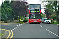
248 bus on Avon Road
Heading for Romford Market, having started at Moor Lane, Cranham. In former times, before this area was fully developed, the 248 still started at Cranham, but ran down St. Mary's Lane to Upminster station - not to Romford, passing under the fairly low railway bridge carrying the Upminster - Grays line. This required use of the low height RLH double deckers on this route. The coachwork was rather ugly compared with the standard RT bus.
Image: © Robin Webster
Taken: 18 Sep 2011
0.16 miles
4
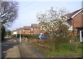
London Loop avoids Hall Lane
For all it's marked as just a yellow road on the map, Hall Lane is a busy local link road and isn't all that pleasant to walk by. So on another of its unavoidable roadside sections it's good that for some of the way the LOOP can go along this parallel service road which is a bit quieter.
Image: © Des Blenkinsopp
Taken: 13 Mar 2014
0.24 miles