IMAGES TAKEN NEAR TO
Wingfield Gardens, UPMINSTER, RM14 1NU
Introduction
This page details the photographs taken nearby to Wingfield Gardens, RM14 1NU by members of the Geograph project.
The Geograph project started in 2005 with the aim of publishing, organising and preserving representative images for every square kilometre of Great Britain, Ireland and the Isle of Man.

There are currently over 7.5m images from over14,400 individuals and you can help contribute to the project by visiting https://www.geograph.org.uk
Image Map (Loading...)


Getting Data...Please wait
Leaflet Map data © OpenStreetMap
Images are licensed for reuse under creativecommons.org/licenses/by-sa/2.0
Notes
- Clicking on the map will re-center to the selected point.
- The higher the marker number, the further away the image location is from the centre of the postcode.
Image Listing (10 Images Found)
Images are licensed for reuse under creativecommons.org/licenses/by-sa/2.0
Image
Details
Distance
1
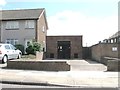
Electricity sub station, Waycross Road
Image: © Alex McGregor
Taken: 14 Aug 2013
0.08 miles
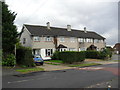
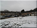
3
Roseberry Gardens
Access road behind houses Upminster.
Image: © Burgess Von Thunen
Taken: 8 Feb 2012
0.18 miles
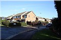
4
Roseberry Close
1960s terraced houses in Upminster.
Image: © Burgess Von Thunen
Taken: 8 Feb 2012
0.18 miles
6
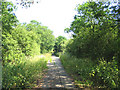
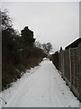
"Nature takes over!", Moor Lane, Cranham, Essex
When M25 motorway was built, this road was closed and in the last fifteen years nature has gradually reclaimed it.
Image: © John Winfield
Taken: 18 Jun 2005
0.20 miles
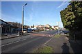
7
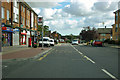
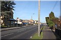
Shops, Avon Road, Cranham
There is a post office here. The bus stop is Front Lane (service 248), which is the intersecting major road ahead.
Image: © Robin Webster
Taken: 18 Sep 2011
0.21 miles