IMAGES TAKEN NEAR TO
Laburnham Gardens, UPMINSTER, RM14 1HX
Introduction
This page details the photographs taken nearby to Laburnham Gardens, RM14 1HX by members of the Geograph project.
The Geograph project started in 2005 with the aim of publishing, organising and preserving representative images for every square kilometre of Great Britain, Ireland and the Isle of Man.

There are currently over 7.5m images from over14,400 individuals and you can help contribute to the project by visiting https://www.geograph.org.uk
Image Map
Images are licensed for reuse under creativecommons.org/licenses/by-sa/2.0
Notes
- Clicking on the map will re-center to the selected point.
- The higher the marker number, the further away the image location is from the centre of the postcode.
Image Listing (16 Images Found)
Images are licensed for reuse under creativecommons.org/licenses/by-sa/2.0
Image
Details
Distance
1
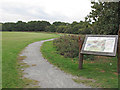
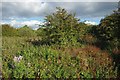
Cranham Brickfields Nature Reserve
This former brickfield has areas of grassland, scrub and woodland.
Wild Essex: http://www.wildessex.net/sites/Cranham%20Brickfields.htm
LB Havering: https://www.havering.gov.uk/Pages/ServiceChild/NatureReserves-CranhamBrickfields.aspx
Image: © Roger Jones
Taken: 27 Sep 2014
0.11 miles
2
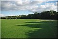
Approach to Cranham Brickfields
This recreation ground is adjacent toImage Which is an area of unmanaged scrub, grass and woodland. It is managed by Havering Council. See
http://www.wildessex.net/sites/Cranham%20Brickfields.htm for more info.
Image: © Glyn Baker
Taken: 16 Oct 2010
0.14 miles
3
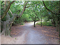
Path through Woodland, Cranham Brickfields Nature Reserve
This former brickfield has areas of grassland, scrub and woodland.
Wild Essex: http://www.wildessex.net/sites/Cranham%20Brickfields.htm
LB Havering: https://www.havering.gov.uk/Pages/ServiceChild/NatureReserves-CranhamBrickfields.aspx
Image: © Roger Jones
Taken: 27 Sep 2014
0.16 miles
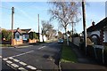
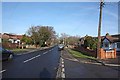
4
Footpath & Bridleway, Moor Lane, Cranham, Essex
Image: © John Salmon
Taken: 21 Jan 2009
0.18 miles
5
Cranham Brickfields
I think this photo confirms Tony Gunton’s description of Cranham Brickfields as “unmanaged grassland and scrub” see http://www.wildessex.net/sites/Cranham%20Brickfields.htm. It is managed by Havering Council.
Image: © Glyn Baker
Taken: 16 Oct 2010
0.18 miles
6
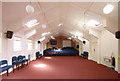
Moor Lane Church, Moor Lane, Cranham
Interior of church but not arranged for service.
Image: © John Salmon
Taken: 6 Apr 2011
0.19 miles
7
Moor Lane Church, Moor Lane, Cranham, Essex
Image: © John Salmon
Taken: 21 Jan 2009
0.19 miles
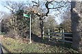
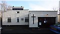
10
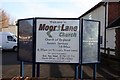
Moor Lane Church, Moor Lane, Cranham, Essex - Notice board
Image: © John Salmon
Taken: 21 Jan 2009
0.19 miles