IMAGES TAKEN NEAR TO
Deyncourt Gardens, UPMINSTER, RM14 1DG
Introduction
This page details the photographs taken nearby to Deyncourt Gardens, RM14 1DG by members of the Geograph project.
The Geograph project started in 2005 with the aim of publishing, organising and preserving representative images for every square kilometre of Great Britain, Ireland and the Isle of Man.

There are currently over 7.5m images from over14,400 individuals and you can help contribute to the project by visiting https://www.geograph.org.uk
Image Map (Loading...)


Getting Data...Please wait
Leaflet Map data © OpenStreetMap
Images are licensed for reuse under creativecommons.org/licenses/by-sa/2.0
Notes
- Clicking on the map will re-center to the selected point.
- The higher the marker number, the further away the image location is from the centre of the postcode.
Image Listing (43 Images Found)
Images are licensed for reuse under creativecommons.org/licenses/by-sa/2.0
Image
Details
Distance
1
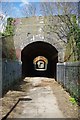
An Upminster Folley
Where I come from urban public footpaths are known as folleys. This one runs under the mainline and underground railway lines between Howard Rd & Deyncourt Gardens Upminster.
Image: © Glyn Baker
Taken: 10 Apr 2010
0.10 miles
8

Claremont Gardens
All of a sudden spring has sprung in Upminster.
Image: © Glyn Baker
Taken: 10 Apr 2010
0.11 miles
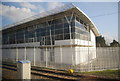
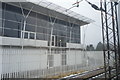
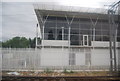
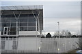
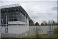
10
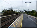
Upminster station
The line between London and Tilbury was opened on 13th April 1854 by the London Tilbury & Southend Railway (LTSR) on their new line to Tilbury, which split from the Eastern Counties Railway (ECR) at Forest Gate. The London, Tilbury & Southend Railway (LTSR) direct line from Bow to Barking (avoiding Stratford and Forest Gate) was constructed from west to east in 1858. The route to Southend, however, was not direct, taking a considerable diversion from Barking via Dagenham Dock to serve the port at Tilbury. Between 1885 and 1888 a new direct route from Barking to Pitsea was constructed, and the station at Upminster opened in 1885. This is now the C2C line.
The Whitechapel & Bow Railway allowed through services of the Metropolitan District Railway to operate through to Upminster from 1902 but the only station between Barking and Upminster was at Dagenham East which was opened in 1885. The Metropolitan District converted to electric trains in 1905. On 12th September 1932 the District line was extended over new tracks alongside the existing line between Barking and Upminster. The present C2C line therefore dates from 1885 and the present District line from 1932. For a fuller history see http://en.wikipedia.org/wiki/Upminster_station
Upminster station is now the eastern terminus of District line trains, with a large depot to the east of the station. It is also served by C2C trains between Fenchurch Street and Shoeburyness as well as the self-contained shuttle service to Romford via Emerson Park Halt. The Romford to Upminster Line was constructed in 1893 as a branch of the London, Tilbury & Southend Railway.
This view looks down the tracks from the up C2C platform. The platform to the right is a bay for trains terminating from the east. For a view of the Underground platforms see http://www.geograph.org.uk/photo/4454287
Image: © Marathon
Taken: 29 Apr 2015
0.15 miles