IMAGES TAKEN NEAR TO
Ruskin Avenue, UPMINSTER, RM14 1AZ
Introduction
This page details the photographs taken nearby to Ruskin Avenue, RM14 1AZ by members of the Geograph project.
The Geograph project started in 2005 with the aim of publishing, organising and preserving representative images for every square kilometre of Great Britain, Ireland and the Isle of Man.

There are currently over 7.5m images from over14,400 individuals and you can help contribute to the project by visiting https://www.geograph.org.uk
Image Map
Images are licensed for reuse under creativecommons.org/licenses/by-sa/2.0
Notes
- Clicking on the map will re-center to the selected point.
- The higher the marker number, the further away the image location is from the centre of the postcode.
Image Listing (17 Images Found)
Images are licensed for reuse under creativecommons.org/licenses/by-sa/2.0
Image
Details
Distance
1
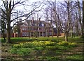
Upminster Court
Built in 1905 for a wealthy businessman, the court ceased being a private residence in 1939.
Since then it has had a varied career as refugee centre, care home, agricultural college etc. Part of the grounds became a golf course.
Currently in business use. http://www.upminster.com/history/places/upminster-court.htm
Image: © Des Blenkinsopp
Taken: 13 Mar 2014
0.10 miles
3
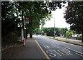
Bus stop and shelter on Hall Lane, Upminster
Image: © JThomas
Taken: 23 Aug 2022
0.12 miles
4
Outbuildings at Upminster Court
Upminster Court was built in 1905. This looks like a coach house, or possibly by 1905 a garage even?
The figure lurking by the wall on the left is a replica Chinese terra cotta warrior. There are several of these in the grounds.
Image: © Des Blenkinsopp
Taken: 13 Mar 2014
0.13 miles
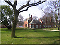
5
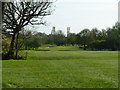
Upminster Golf Club
Looking from the northern end of the course.
Image: © Robin Webster
Taken: 9 Apr 2011
0.14 miles
6

Interior of the Tithe Barn at Upminster, Essex
The barn measuring some 138 feet long by 40 feet wide is of timber framed construction clad in horizontal clapboards and roofed in thatch. It was built in the mid fifteenth century as part of the much older Upminster Hall farm. The manor was given to the Abbey of Waltham by Lord Harold a few years before the Norman conquest took place. The barn is now home to a museum of country life. (note the rooster on the cart)
Image: © Derek Voller
Taken: 31 May 2014
0.15 miles
7

Interior of the Tithe Barn at Upminster, Essex
This old horse drawn cart (Haywain?) is an exhibit in the museum housed in the 15th century thatched barn, built as part of the Upminster Hall estate.
Image: © Derek Voller
Taken: 31 May 2014
0.15 miles
8
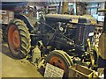
Fordson tractor. An exhibit at the Tithe Barn Museum
Image: © Derek Voller
Taken: 31 May 2014
0.15 miles
9
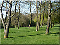
Trees on the golf course
At Upminster Golf Club.
Image: © Robin Webster
Taken: 9 Apr 2011
0.15 miles
10
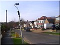
A Leaning Lamp Post
This is down River Drive on another roadside section of the London Loop walk.
Image: © Des Blenkinsopp
Taken: 13 Mar 2014
0.16 miles