IMAGES TAKEN NEAR TO
Hall Lane, UPMINSTER, RM14 1AG
Introduction
This page details the photographs taken nearby to Hall Lane, RM14 1AG by members of the Geograph project.
The Geograph project started in 2005 with the aim of publishing, organising and preserving representative images for every square kilometre of Great Britain, Ireland and the Isle of Man.

There are currently over 7.5m images from over14,400 individuals and you can help contribute to the project by visiting https://www.geograph.org.uk
Image Map
Images are licensed for reuse under creativecommons.org/licenses/by-sa/2.0
Notes
- Clicking on the map will re-center to the selected point.
- The higher the marker number, the further away the image location is from the centre of the postcode.
Image Listing (5 Images Found)
Images are licensed for reuse under creativecommons.org/licenses/by-sa/2.0
Image
Details
Distance
1
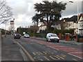
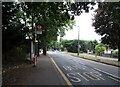
Hall Lane, Upminster
Hall Lane leads north away from Upminster town centre towards a junction with the A127. The bus stop is served by two routes, 248 and 347, one of which calls here on its way from Romford and the other on its way to Romford.
Image: © Stephen McKay
Taken: 13 Feb 2020
0.16 miles
2
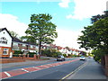
Hall Lane, Upminster
A view north along Hall Lane.
Image: © Malc McDonald
Taken: 16 May 2015
0.17 miles
3
Bus stop and shelter on Hall Lane, Upminster
Image: © JThomas
Taken: 23 Aug 2022
0.24 miles