IMAGES TAKEN NEAR TO
Sims Close, ROMFORD, RM1 3QT
Introduction
This page details the photographs taken nearby to Sims Close, RM1 3QT by members of the Geograph project.
The Geograph project started in 2005 with the aim of publishing, organising and preserving representative images for every square kilometre of Great Britain, Ireland and the Isle of Man.

There are currently over 7.5m images from over14,400 individuals and you can help contribute to the project by visiting https://www.geograph.org.uk
Image Map
Images are licensed for reuse under creativecommons.org/licenses/by-sa/2.0
Notes
- Clicking on the map will re-center to the selected point.
- The higher the marker number, the further away the image location is from the centre of the postcode.
Image Listing (43 Images Found)
Images are licensed for reuse under creativecommons.org/licenses/by-sa/2.0
Image
Details
Distance
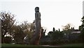
4
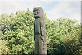
Lodge Farm Park Totem Sculpture, Romford (Close-up)
Carved from Atlantic Blue Cedar.
Image: © Richard Winch
Taken: 13 May 2017
0.10 miles
5
Lodge Farm Park Totem Sculpture, Romford
Carved from Atlantic Blue Cedar.
Image: © Richard Winch
Taken: 13 May 2017
0.10 miles
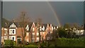
7
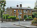
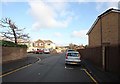
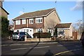
Houses on corner of Western Road, Romford
Image: © Robin Webster
Taken: 11 Jun 2011
0.11 miles
9
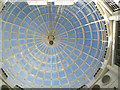
The dome - Liberty 2
The dome at the re-vamped Liberty 2 centre, Romford
Image: © John Winfield
Taken: 3 Nov 2006
0.11 miles
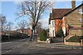
10
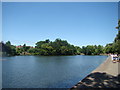
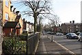
View of the lake in Raphael Park, looking downstream
Looking south-southeast.
Image: © Robert Lamb
Taken: 4 Jul 2010
0.11 miles