IMAGES TAKEN NEAR TO
Mercury Gardens, ROMFORD, RM1 3HN
Introduction
This page details the photographs taken nearby to Mercury Gardens, RM1 3HN by members of the Geograph project.
The Geograph project started in 2005 with the aim of publishing, organising and preserving representative images for every square kilometre of Great Britain, Ireland and the Isle of Man.

There are currently over 7.5m images from over14,400 individuals and you can help contribute to the project by visiting https://www.geograph.org.uk
Image Map
Images are licensed for reuse under creativecommons.org/licenses/by-sa/2.0
Notes
- Clicking on the map will re-center to the selected point.
- The higher the marker number, the further away the image location is from the centre of the postcode.
Image Listing (115 Images Found)
Images are licensed for reuse under creativecommons.org/licenses/by-sa/2.0
Image
Details
Distance

4
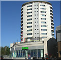
Romford - New Development, Liberty 2
Recently completed block of private apartments on the old Dolphin site. See Image when under construction.
Image: © John Winfield
Taken: 3 Nov 2006
0.02 miles
6
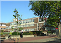
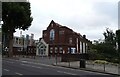
Romford Police Station
Located in Main Road, Romford - divisional headquarters for Havering Division of the Metropolitan Police
Image: © John Winfield
Taken: 3 Nov 2006
0.05 miles
7
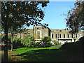
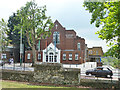
Romford - Town Hall
Town Hall for the London Borough of Havering, which was built in 1935 in the 'International Moderne' style and is a Grade II listed building
Image: © John Winfield
Taken: 3 Nov 2006
0.05 miles
8
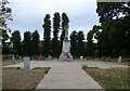
Romford War Memorial, Coronation Gardens
In 1970 the Romford War Memorial was re-erected here when the new Ring Road was built.
Image: © JThomas
Taken: 24 Aug 2022
0.06 miles
9
View of the Liberty complex from Raphael Park
This is a view of the Liberty shopping centre, looking southeast towards Romford town centre.
Image: © Robert Lamb
Taken: 4 Jul 2010
0.06 miles
10
Ludwigshafen Place
Romford is twinned with Ludwigshafen; this area in the middle of a roundabout was named in 1973. Read about the art work at Image
Image: © Glyn Baker
Taken: 3 Jul 2012
0.06 miles