IMAGES TAKEN NEAR TO
Anglesey Drive, RAINHAM, RM13 9UH
Introduction
This page details the photographs taken nearby to Anglesey Drive, RM13 9UH by members of the Geograph project.
The Geograph project started in 2005 with the aim of publishing, organising and preserving representative images for every square kilometre of Great Britain, Ireland and the Isle of Man.

There are currently over 7.5m images from over14,400 individuals and you can help contribute to the project by visiting https://www.geograph.org.uk
Image Map
Images are licensed for reuse under creativecommons.org/licenses/by-sa/2.0
Notes
- Clicking on the map will re-center to the selected point.
- The higher the marker number, the further away the image location is from the centre of the postcode.
Image Listing (189 Images Found)
Images are licensed for reuse under creativecommons.org/licenses/by-sa/2.0
Image
Details
Distance
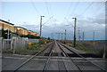
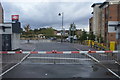
3
Looking down the line from Rainham station
The construction of the London, Tilbury & Southend Railway line was authorised by Parliament on 17th June 1852. The first section was opened between Forest Gate junction on the Eastern Counties Railway and Tilbury, via Barking and Grays on 13th April 1854. The London, Tilbury & Southend Railway direct line from Bow to Barking (avoiding Stratford and Forest Gate) was constructed from west to east in 1858. Rainham station opened with the line in 1854.
The Channel Tunnel Rail Link passes immediately to the south of the station. The first Eurostars ran along the line on 6th November 2007 following the completion of High Speed 1 and the opening of St Pancras International. Southeastern Javelins now also use the line.
This looks across the level crossing immediately to the east of the station. High Speed 1 is to the left. The line ahead is dead straight, almost to Purfleet station. The crossing is now mainly used by foot passengers accessing the up platform as the road was severed when HS1 was constructed. The road now just leads to private railway land between the C2C line and HS1.
Image: © Marathon
Taken: 1 Jun 2016
0.06 miles

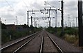
8
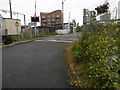
The level crossing at Ferry Lane
The construction of the London, Tilbury & Southend Railway line was authorised by Parliament on 17th June 1852. The first section was opened between Forest Gate junction on the Eastern Counties Railway and Tilbury, via Barking and Grays on 13th April 1854. The London, Tilbury & Southend Railway direct line from Bow to Barking (avoiding Stratford and Forest Gate) was constructed from west to east in 1858. Rainham station opened with the line in 1854.
The Channel Tunnel Rail Link passes immediately to the south of the station. The first Eurostars ran along the line on 6th November 2007 following the completion of High Speed 1 and the opening of St Pancras International. Southeastern Javelins now also use the line.
This looks across the level crossing immediately to the east of the station. High Speed 1 is behind. The crossing is now mainly used by foot passengers accessing the up platform as the Ferry Lane was severed when HS1 was constructed. The road now just leads to private railway land between the C2C line and HS1.
Image: © Marathon
Taken: 1 Jun 2016
0.07 miles
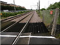
9
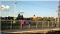
View of St. Helen's and St. Giles' Rainham Parish Church from the platform at Rainham station
Looking north-northeast.
Image: © Robert Lamb
Taken: 29 Apr 2015
0.07 miles
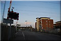
10
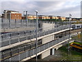
New footbridge near Rainham Railway Station
As seen from the bridge/path from Rainham Marshes.
These gentle slopes allow cycles and prams to cross over the highspeed line.
In the background a High Speed train passes through the station heading towards Ebbfleet (in Kent).
Image: © David Anstiss
Taken: 7 Nov 2012
0.07 miles