IMAGES TAKEN NEAR TO
Ferro Road, RAINHAM, RM13 9UD
Introduction
This page details the photographs taken nearby to Ferro Road, RM13 9UD by members of the Geograph project.
The Geograph project started in 2005 with the aim of publishing, organising and preserving representative images for every square kilometre of Great Britain, Ireland and the Isle of Man.

There are currently over 7.5m images from over14,400 individuals and you can help contribute to the project by visiting https://www.geograph.org.uk
Image Map (Loading...)


Getting Data...Please wait
Leaflet Map data © OpenStreetMap
Images are licensed for reuse under creativecommons.org/licenses/by-sa/2.0
Notes
- Clicking on the map will re-center to the selected point.
- The higher the marker number, the further away the image location is from the centre of the postcode.
Image Listing (179 Images Found)
Images are licensed for reuse under creativecommons.org/licenses/by-sa/2.0
Image
Details
Distance
1
Benchmark on #121 Wennington Road
Ordnance Survey cut mark benchmark described on the Bench Mark Database at http://www.bench-marks.org.uk/bm36093
Image: © Roger Templeman
Taken: 21 Nov 2010
0.07 miles
2
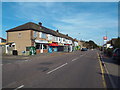
Wennington Road, Rainham
Wennington Road in Rainham, on the outer fringe of east London.
Image: © Malc McDonald
Taken: 28 Aug 2017
0.08 miles
4
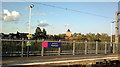
View of St. Helen's and St. Giles' Rainham Parish Church from the platform at Rainham station
Looking north-northeast.
Image: © Robert Lamb
Taken: 29 Apr 2015
0.11 miles
5
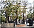
Rainham Hall (front)
Rainham Hall was built in 1729 for Captain John Harle, a merchant and shipowner and has been owned by the National Trust since 1949. It is described in Pevsner's 'Buildings of England' as "sumptuous but small".
Image: © David Kemp
Taken: 25 Oct 2008
0.11 miles
7

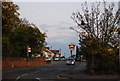
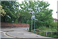
Signpost, junction of Ferry Lane & Broadway, Rainham
Image: © N Chadwick
Taken: 8 Nov 2009
0.11 miles
9

The garden of Rainham Hall
Rainham Hall was built in 1729 for Captain John Harle, a sea-captain and merchant from South Shields. The house was transferred to the National Trust in 1949, but let to a number of private tenants. It remained closed to the public until late 2015. The garden is surprisingly large after viewing the frontage of the house.
The National Trust's website for the house can be seen at http://www.nationaltrust.org.uk/rainham-hall and the Wikpedia description is at https://en.wikipedia.org/wiki/Rainham_Hall
A nice description in The Guardian of the house's reopening can be seen at https://www.theguardian.com/artanddesign/2015/oct/08/rainham-hall-house-essex-national-trust-restored See also http://londonist.com/2015/10/rainham-hall
Image: © Marathon
Taken: 1 Jun 2016
0.12 miles
10

The garden of Rainham Hall
Rainham Hall was built in 1729 for Captain John Harle, a sea-captain and merchant from South Shields. The house was transferred to the National Trust in 1949, but let to a number of private tenants. It remained closed to the public until late 2015. The garden is surprisingly large after viewing the frontage of the house.
The National Trust's website for the house can be seen at http://www.nationaltrust.org.uk/rainham-hall and the Wikpedia description is at https://en.wikipedia.org/wiki/Rainham_Hall
A nice description in The Guardian of the house's reopening can be seen at https://www.theguardian.com/artanddesign/2015/oct/08/rainham-hall-house-essex-national-trust-restored See also http://londonist.com/2015/10/rainham-hall
Image: © Marathon
Taken: 1 Jun 2016
0.12 miles