IMAGES TAKEN NEAR TO
Mitchell Close, RAINHAM, RM13 9QY
Introduction
This page details the photographs taken nearby to Mitchell Close, RM13 9QY by members of the Geograph project.
The Geograph project started in 2005 with the aim of publishing, organising and preserving representative images for every square kilometre of Great Britain, Ireland and the Isle of Man.

There are currently over 7.5m images from over14,400 individuals and you can help contribute to the project by visiting https://www.geograph.org.uk
Image Map
Images are licensed for reuse under creativecommons.org/licenses/by-sa/2.0
Notes
- Clicking on the map will re-center to the selected point.
- The higher the marker number, the further away the image location is from the centre of the postcode.
Image Listing (6 Images Found)
Images are licensed for reuse under creativecommons.org/licenses/by-sa/2.0
Image
Details
Distance
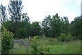
3
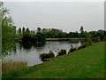
Lake in the Nature Reserve
Another bit of wetland habitat on the Ingrebourne Valley reserve. http://www.lnr.naturalengland.org.uk/Special/lnr/lnr_details.asp?C=0&N=&ID=1244
Image: © Des Blenkinsopp
Taken: 4 Jun 2013
0.19 miles
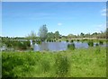
5
Albyns Farm Pond
This pond is to the east of Albyns Farm on the Hornchurch Country Park. The London Loop long distance path runs past the far end of the pond
Image: © Glyn Baker
Taken: 5 Sep 2005
0.24 miles