IMAGES TAKEN NEAR TO
Magnum Close, RAINHAM, RM13 9PU
Introduction
This page details the photographs taken nearby to Magnum Close, RM13 9PU by members of the Geograph project.
The Geograph project started in 2005 with the aim of publishing, organising and preserving representative images for every square kilometre of Great Britain, Ireland and the Isle of Man.

There are currently over 7.5m images from over14,400 individuals and you can help contribute to the project by visiting https://www.geograph.org.uk
Image Map
Images are licensed for reuse under creativecommons.org/licenses/by-sa/2.0
Notes
- Clicking on the map will re-center to the selected point.
- The higher the marker number, the further away the image location is from the centre of the postcode.
Image Listing (5 Images Found)
Images are licensed for reuse under creativecommons.org/licenses/by-sa/2.0
Image
Details
Distance
1
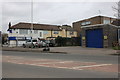
New Road, Rainham
Looking at the back of shops on Upminster Road North
Image: © David Howard
Taken: 22 Feb 2020
0.16 miles
2

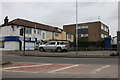
Benchmark on #21 Wentworth Way
Ordnance Survey cut mark benchmark described on the Bench Mark Database at http://www.bench-marks.org.uk/bm36090
Image: © Roger Templeman
Taken: 21 Nov 2010
0.18 miles
4
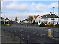
Road junction on Wennington Road
The main road leads from Wennington left towards Rainham.
Lambs Lane South leads right and Ingrebourne Road leads straight on.
Image: © David Anstiss
Taken: 7 Nov 2012
0.24 miles
5
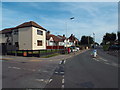
Wennington Road, Rainham
Wennington Road heading out of Rainham, on the outer fringe of east London.
Image: © Malc McDonald
Taken: 28 Aug 2017
0.24 miles