IMAGES TAKEN NEAR TO
Steel Approach, RAINHAM, RM13 9PF
Introduction
This page details the photographs taken nearby to Steel Approach, RM13 9PF by members of the Geograph project.
The Geograph project started in 2005 with the aim of publishing, organising and preserving representative images for every square kilometre of Great Britain, Ireland and the Isle of Man.

There are currently over 7.5m images from over14,400 individuals and you can help contribute to the project by visiting https://www.geograph.org.uk
Image Map
Images are licensed for reuse under creativecommons.org/licenses/by-sa/2.0
Notes
- Clicking on the map will re-center to the selected point.
- The higher the marker number, the further away the image location is from the centre of the postcode.
Image Listing (24 Images Found)
Images are licensed for reuse under creativecommons.org/licenses/by-sa/2.0
Image
Details
Distance
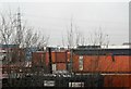
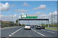
3

Container Stack
Just one of a number of container depot's in the Rainham area
Image: © Glyn Baker
Taken: 12 Aug 2005
0.13 miles
7
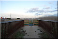
Rainham to Purfleet Footpath off Ferry Lane
http://www.walklondon.org.uk/section.asp?S=24
Image: © N Chadwick
Taken: 8 Nov 2009
0.19 miles
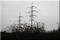
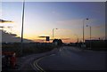
8

The sunset 20 minutes later
This was our location about 20 minutes later. We are now on the A13 just outside Rainham and approaching the Dagenham Ford Motor Works, and the sunset is still here in all its glory! This time, however, I managed to include street furniture and a nearby pylon in order to add to the silhouette effect. This view was taken from the London-bound A13 looking west-northwest.
Image: © Robert Lamb
Taken: 3 May 2009
0.20 miles
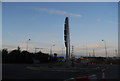
10
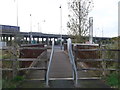
National Cycle Network 13 near Ferry Lane roundabout North
The cyclepath leads from Rainham Railway Station through the Rainham Marshes towards the A13 (dual carriageway, seen in the background), the cyclepath then leads (through another section of the marshes to Coldharbour Lane).
Compare with Image
Image: © David Anstiss
Taken: 7 Nov 2012
0.20 miles