IMAGES TAKEN NEAR TO
Wennington Road, RAINHAM, RM13 9EF
Introduction
This page details the photographs taken nearby to Wennington Road, RM13 9EF by members of the Geograph project.
The Geograph project started in 2005 with the aim of publishing, organising and preserving representative images for every square kilometre of Great Britain, Ireland and the Isle of Man.

There are currently over 7.5m images from over14,400 individuals and you can help contribute to the project by visiting https://www.geograph.org.uk
Image Map
Images are licensed for reuse under creativecommons.org/licenses/by-sa/2.0
Notes
- Clicking on the map will re-center to the selected point.
- The higher the marker number, the further away the image location is from the centre of the postcode.
Image Listing (13 Images Found)
Images are licensed for reuse under creativecommons.org/licenses/by-sa/2.0
Image
Details
Distance
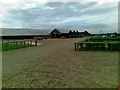
1
A1306 New Road
As seen from near to Wennington Hall Farm.
This road leads towards Rainham.
In the background on the right, a new leisure centre is being built.
Image: © David Anstiss
Taken: 7 Nov 2012
0.07 miles
2
Sign for Willow Farm restaurant, Premier Inn Rainham, Wennington
Image: © Mike Pennington
Taken: 12 Sep 2023
0.08 miles
3
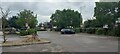
Car park at Premier Inn Rainham, Wennington
Image: © Mike Pennington
Taken: 12 Sep 2023
0.10 miles
4
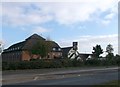
Willow Farm, Premier Inn
As seen from the A1306 New Road.
Large red motel and accompanying 'Tabletable' restaurant.
Image: © David Anstiss
Taken: 7 Nov 2012
0.10 miles
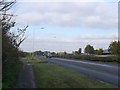
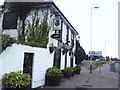
5

Willow Farm Premier Inn
Looking along the A1306 towards Rainham. Look at the sky not a jet trace in sight one small plus to CV-19
Image: © Glyn Baker
Taken: 4 Apr 2020
0.11 miles
7
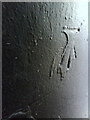
Benchmark on Lennards public house
Ordnance Survey cut mark benchmark described on the Bench Mark Database at http://www.bench-marks.org.uk/bm32603
Image: © Roger Templeman
Taken: 21 Nov 2010
0.14 miles
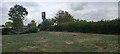
8

Wennington Fire Station
Looking east the last LFCDA station before Essex takes over
Image: © Glyn Baker
Taken: 11 Aug 2005
0.14 miles
9
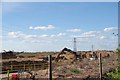
Wennington Quarry
When this sand pit is exhausted permission has been sought to turn it into a landfill for "inert" materials. I assume this means hard core, fly ash, and demolition waste but not domestic rubbish. (Not a jet trace to be seen)
Image: © Glyn Baker
Taken: 4 Apr 2020
0.15 miles