IMAGES TAKEN NEAR TO
Ashwood Avenue, RAINHAM, RM13 9AS
Introduction
This page details the photographs taken nearby to Ashwood Avenue, RM13 9AS by members of the Geograph project.
The Geograph project started in 2005 with the aim of publishing, organising and preserving representative images for every square kilometre of Great Britain, Ireland and the Isle of Man.

There are currently over 7.5m images from over14,400 individuals and you can help contribute to the project by visiting https://www.geograph.org.uk
Image Map (Loading...)


Getting Data...Please wait
Leaflet Map data © OpenStreetMap
Images are licensed for reuse under creativecommons.org/licenses/by-sa/2.0
Notes
- Clicking on the map will re-center to the selected point.
- The higher the marker number, the further away the image location is from the centre of the postcode.
Image Listing (8 Images Found)
Images are licensed for reuse under creativecommons.org/licenses/by-sa/2.0
Image
Details
Distance
1
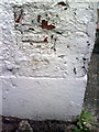
Benchmark on #157 Upminster Road South
Ordnance Survey cut mark benchmark described on the Bench Mark Database at http://www.bench-marks.org.uk/bm36091
Image: © Roger Templeman
Taken: 21 Nov 2010
0.06 miles
2

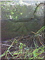
Benchmark on Rainham Village Primary School & Nursery
Ordnance Survey cut mark benchmark described on the Bench Mark Database at http://www.bench-marks.org.uk/bm36100
Image: © Roger Templeman
Taken: 21 Nov 2010
0.12 miles
3

Ingrebourne River in Rainham (3)
This is the view looking upstream from the A1306 New Road bridge.
Image: © Nigel Cox
Taken: 7 Jul 2016
0.14 miles
4
Benchmark on river bridge on New Road
Ordnance Survey cut mark benchmark described on the Bench Mark Database at http://www.bench-marks.org.uk/bm36101
Image: © Roger Templeman
Taken: 21 Nov 2010
0.16 miles
5
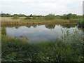
Rainham: Pond north of the A1306 New Road
This pond is one of several recently established here along the Ingrebourne River. The photographer states recent because they do not appear on any large scale historic Ordnance Survey mapping currently available online. The photographer is also uncertain of their purpose - maybe they are balancing ponds that can temporarily store excess water.
Image: © Nigel Cox
Taken: 7 Jul 2016
0.17 miles
6
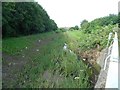
Ingrebourne River in Rainham (2)
This is the view looking downstream from the A1306 New Road bridge.
Image: © Nigel Cox
Taken: 7 Jul 2016
0.18 miles
7

Gospel Hall, Rainham
On Cowper Road.
Used by Praise Communion Church.
Image: © David Anstiss
Taken: 7 Nov 2012
0.24 miles
8

Benchmark on #21 Wentworth Way
Ordnance Survey cut mark benchmark described on the Bench Mark Database at http://www.bench-marks.org.uk/bm36090
Image: © Roger Templeman
Taken: 21 Nov 2010
0.25 miles