IMAGES TAKEN NEAR TO
Rainham Road, RAINHAM, RM13 8SP
Introduction
This page details the photographs taken nearby to Rainham Road, RM13 8SP by members of the Geograph project.
The Geograph project started in 2005 with the aim of publishing, organising and preserving representative images for every square kilometre of Great Britain, Ireland and the Isle of Man.

There are currently over 7.5m images from over14,400 individuals and you can help contribute to the project by visiting https://www.geograph.org.uk
Image Map (Loading...)


Getting Data...Please wait
Leaflet Map data © OpenStreetMap
Images are licensed for reuse under creativecommons.org/licenses/by-sa/2.0
Notes
- Clicking on the map will re-center to the selected point.
- The higher the marker number, the further away the image location is from the centre of the postcode.
Image Listing (38 Images Found)
Images are licensed for reuse under creativecommons.org/licenses/by-sa/2.0
Image
Details
Distance
1
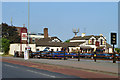
The Albion
This sprawling assembly of buildings was very popular on a perfect Easter Day. The taller building behind on the left is a telephone exchange.
Image: © Robin Webster
Taken: 24 Apr 2011
0.02 miles
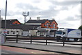
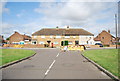
3
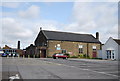
La Salette Parish Hall
Roman Catholic, on a site including a church and school.
Image: © Robin Webster
Taken: 24 Apr 2011
0.04 miles
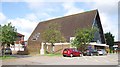
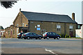
6
Church building, Our Lady of La Salette Catholic Church
Image: © N Chadwick
Taken: 18 Jun 2011
0.04 miles