IMAGES TAKEN NEAR TO
Sparrow Street, RAINHAM, RM13 8LY
Introduction
This page details the photographs taken nearby to Sparrow Street, RM13 8LY by members of the Geograph project.
The Geograph project started in 2005 with the aim of publishing, organising and preserving representative images for every square kilometre of Great Britain, Ireland and the Isle of Man.

There are currently over 7.5m images from over14,400 individuals and you can help contribute to the project by visiting https://www.geograph.org.uk
Image Map (Loading...)


Getting Data...Please wait
Leaflet Map data © OpenStreetMap
Images are licensed for reuse under creativecommons.org/licenses/by-sa/2.0
Notes
- Clicking on the map will re-center to the selected point.
- The higher the marker number, the further away the image location is from the centre of the postcode.
Image Listing (142 Images Found)
Images are licensed for reuse under creativecommons.org/licenses/by-sa/2.0
Image
Details
Distance
1
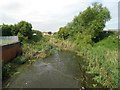
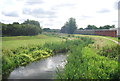
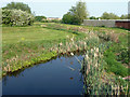
Rainham Creek
This is the view of the upstream end of Rainham Creek from the Red Bridge, which is, according to old large scale Ordnance Survey maps, historically the normal tidal limit.
Image: © Nigel Cox
Taken: 7 Jul 2016
0.04 miles
5
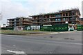
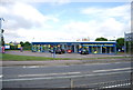
Knightswood Place on New Road, Rainham
This replaced an industrial area.
Image: © David Howard
Taken: 19 Mar 2023
0.08 miles

8
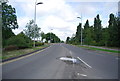
Ingrebourne at Red Bridge
Formerly close to the tidal limit up Rainham Creek, before it was dammed off.
Image: © Robin Webster
Taken: 24 Apr 2011
0.09 miles