IMAGES TAKEN NEAR TO
Philip Road, RAINHAM, RM13 8LT
Introduction
This page details the photographs taken nearby to Philip Road, RM13 8LT by members of the Geograph project.
The Geograph project started in 2005 with the aim of publishing, organising and preserving representative images for every square kilometre of Great Britain, Ireland and the Isle of Man.

There are currently over 7.5m images from over14,400 individuals and you can help contribute to the project by visiting https://www.geograph.org.uk
Image Map
Images are licensed for reuse under creativecommons.org/licenses/by-sa/2.0
Notes
- Clicking on the map will re-center to the selected point.
- The higher the marker number, the further away the image location is from the centre of the postcode.
Image Listing (10 Images Found)
Images are licensed for reuse under creativecommons.org/licenses/by-sa/2.0
Image
Details
Distance
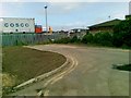
1

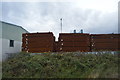
Rainham Steel on New Road
This was the A13 until the new road was built to the south. I had only heard of them as they sponsor football teams.
Image: © David Howard
Taken: 19 Mar 2023
0.09 miles
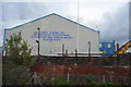
2
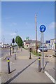
A1306 Cycleway
This route will take you to Barking and beyond
Image: © Glyn Baker
Taken: 10 May 2020
0.13 miles
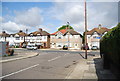
4

New Road, Rainham
The flats were completed in 2022.
Image: © David Howard
Taken: 19 Mar 2023
0.18 miles
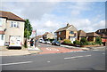
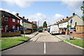
9
Junction of Christchurch Avenue and Cherry Tree Lane
Image: © N Chadwick
Taken: 18 Jun 2011
0.24 miles