IMAGES TAKEN NEAR TO
Apple Tree Lane, RAINHAM, RM13 8FQ
Introduction
This page details the photographs taken nearby to Apple Tree Lane, RM13 8FQ by members of the Geograph project.
The Geograph project started in 2005 with the aim of publishing, organising and preserving representative images for every square kilometre of Great Britain, Ireland and the Isle of Man.

There are currently over 7.5m images from over14,400 individuals and you can help contribute to the project by visiting https://www.geograph.org.uk
Image Map
Images are licensed for reuse under creativecommons.org/licenses/by-sa/2.0
Notes
- Clicking on the map will re-center to the selected point.
- The higher the marker number, the further away the image location is from the centre of the postcode.
Image Listing (20 Images Found)
Images are licensed for reuse under creativecommons.org/licenses/by-sa/2.0
Image
Details
Distance
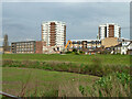
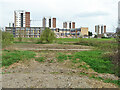
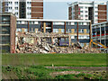
1
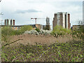
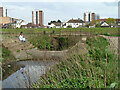
Flats, Rainham, 2011
The high blocks and some of the others were later demolished.
Image: © Robin Webster
Taken: 2 Apr 2011
0.07 miles
5
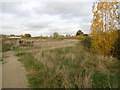
Beam Valley Country Park
This is near the southern entrance to Beam Valley Country Park from New Road. See http://www.thameschase.org.uk/visitor-centres/dagenham-and-romford/beam-valley-country-park and https://en.wikipedia.org/wiki/Beam_Valley_Country_Park for more information on the park.
Image: © Marathon
Taken: 16 Nov 2016
0.13 miles
6
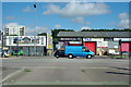
Premises on New Road, Rainham
New Road, but old A13. Now the A1306.
Image: © Robin Webster
Taken: 18 Sep 2011
0.17 miles
7
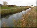
Weir and footbridge, Wantz Stream
Just before the junction with the Beam River.
Image: © Robin Webster
Taken: 2 Apr 2011
0.18 miles
8
On the banks of the Beam River
The Beam River is seen here looking upriver. The structure in the distance is for flood control. This is the southern entrance to Beam Valley Country Park. See http://www.thameschase.org.uk/visitor-centres/dagenham-and-romford/beam-valley-country-park and https://en.wikipedia.org/wiki/Beam_Valley_Country_Park for more information on the park.
Above the confluence with the Ravensbourne, near Harrow Lodge Park, the Beam River is known as the River Rom. The Beam flows into the Thames at Dagenham - see https://en.wikipedia.org/wiki/River_Rom for more information on the Beam River.
Image: © Marathon
Taken: 16 Nov 2016
0.18 miles
9
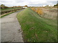
Along the bank of the Beam River
The Beam River is seen here looking upriver from near New Road. The structure in the distance is for flood control and the bank in the centre of the photograph is clearly also a flood control measure. This is near the southern entrance to Beam Valley Country Park. See http://www.thameschase.org.uk/visitor-centres/dagenham-and-romford/beam-valley-country-park and https://en.wikipedia.org/wiki/Beam_Valley_Country_Park for more information on the park.
Above the confluence with the Ravensbourne, near Harrow Lodge Park, the Beam River is known as the River Rom. The Beam flows into the Thames at Dagenham - see https://en.wikipedia.org/wiki/River_Rom for more information on the Beam River.
Image: © Marathon
Taken: 16 Nov 2016
0.18 miles
10
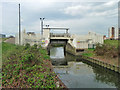
Beam Auto Sluice 55BE0102/C501
So says the Environment Agency sign on the fence. Combined with an earth wall across the rest of the valley, it appears to be a recent measure to prevent extreme high tides in the Thames progressing up the Beam valley.
Image: © Robin Webster
Taken: 2 Apr 2011
0.18 miles