IMAGES TAKEN NEAR TO
Willoughby Drive, RAINHAM, RM13 7SX
Introduction
This page details the photographs taken nearby to Willoughby Drive, RM13 7SX by members of the Geograph project.
The Geograph project started in 2005 with the aim of publishing, organising and preserving representative images for every square kilometre of Great Britain, Ireland and the Isle of Man.

There are currently over 7.5m images from over14,400 individuals and you can help contribute to the project by visiting https://www.geograph.org.uk
Image Map
Images are licensed for reuse under creativecommons.org/licenses/by-sa/2.0
Notes
- Clicking on the map will re-center to the selected point.
- The higher the marker number, the further away the image location is from the centre of the postcode.
Image Listing (17 Images Found)
Images are licensed for reuse under creativecommons.org/licenses/by-sa/2.0
Image
Details
Distance
1
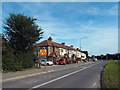
Dagenham Road, South Hornchurch
A view of the eastbound carriageway of Dagenham Road, in South Hornchurch.
Image: © Malc McDonald
Taken: 28 Aug 2017
0.10 miles
2
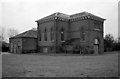
Dagenham Pumping Station
Essex water Co station with a pair of inverted vertical triple expansion pumping engines. These have since been removed. It was typical of the company's stations and similar buildings were to be seen at Ilford and Roding.
Image: © Chris Allen
Taken: 21 Nov 1985
0.11 miles
3
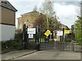
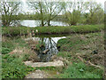
Pumping station by Beam River
A grade II listed building, 'after 1897'.
Image: © Robin Webster
Taken: 2 Apr 2011
0.14 miles
4
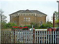
Pumping station by Beam River
A grade II listed building, 'after 1897'.
Image: © Robin Webster
Taken: 2 Apr 2011
0.14 miles
6
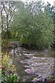
Beam River
This is the Beam River in the Image This river drains around 66sq km of the surrounding real estate. http://www.barking-dagenham.gov.uk/8-leisure-envir/park-country/beam-valley.html there is no way the rocks are part of the natural geology.
Image: © Glyn Baker
Taken: 3 Oct 2010
0.17 miles
7
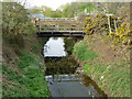
Bridges over Beam River
Between a water company depot on the left and a pumping station on the right.
Image: © Robin Webster
Taken: 2 Apr 2011
0.17 miles
8
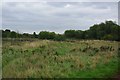
Dagenham!
Not the sort of landscape you expect in Dagenham! This is part of the Image
Image: © Glyn Baker
Taken: 3 Oct 2010
0.18 miles
9
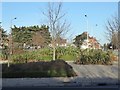
Roundabout where Rainham Road meets Dagenham Road
This is South Hornchurch Rainham Road is to the left and straight on while Dagenham Road is to the left. Quite a bit of effort has gone into landscaping this roundabout.
Image: © Marathon
Taken: 14 Dec 2016
0.19 miles
10
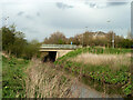
Dagenham Beam Bridge
The A1112 Rainham Road South / Dagenham Road crosses - the name changes at the river boundary between The London Boroughs of Barking and Dagenham and of Havering.
Image: © Robin Webster
Taken: 2 Apr 2011
0.19 miles