IMAGES TAKEN NEAR TO
Brentwood Road, ROMFORD, RM1 2SH
Introduction
This page details the photographs taken nearby to Brentwood Road, RM1 2SH by members of the Geograph project.
The Geograph project started in 2005 with the aim of publishing, organising and preserving representative images for every square kilometre of Great Britain, Ireland and the Isle of Man.

There are currently over 7.5m images from over14,400 individuals and you can help contribute to the project by visiting https://www.geograph.org.uk
Image Map
Images are licensed for reuse under creativecommons.org/licenses/by-sa/2.0
Notes
- Clicking on the map will re-center to the selected point.
- The higher the marker number, the further away the image location is from the centre of the postcode.
Image Listing (7 Images Found)
Images are licensed for reuse under creativecommons.org/licenses/by-sa/2.0
Image
Details
Distance
2
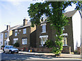
Victorian Cottages, Globe Road, Romford, Essex
Image: © John Winfield
Taken: 12 Jul 2005
0.19 miles
3
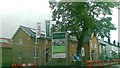
Brentwood Rd, Heath Park
If you look behind the flats on the horizon you can make out some of the towers of Canary Wharf.
Image: © Glyn Baker
Taken: 2 Dec 2012
0.24 miles
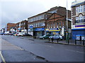
4
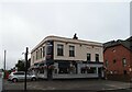
The Victoria public house, Romford
On Victoria Road.
See Image] for sign.
Image: © JThomas
Taken: 23 Aug 2022
0.24 miles
5
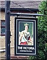
Sign for the Victoria public house, Romford
See Image] for context.
Image: © JThomas
Taken: 23 Aug 2022
0.24 miles
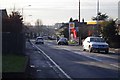
7
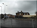
Thurloe Gardens, Romford
Looking towards Victoria Road
Image: © David Howard
Taken: 5 Mar 2017
0.25 miles