IMAGES TAKEN NEAR TO
Victoria Road, ROMFORD, RM1 2JB
Introduction
This page details the photographs taken nearby to Victoria Road, RM1 2JB by members of the Geograph project.
The Geograph project started in 2005 with the aim of publishing, organising and preserving representative images for every square kilometre of Great Britain, Ireland and the Isle of Man.

There are currently over 7.5m images from over14,400 individuals and you can help contribute to the project by visiting https://www.geograph.org.uk
Image Map
Images are licensed for reuse under creativecommons.org/licenses/by-sa/2.0
Notes
- Clicking on the map will re-center to the selected point.
- The higher the marker number, the further away the image location is from the centre of the postcode.
Image Listing (102 Images Found)
Images are licensed for reuse under creativecommons.org/licenses/by-sa/2.0
Image
Details
Distance
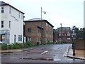
1
Bus-only road, Romford
Bus-only section of Victoria Road, Romford.
Image: © Malc McDonald
Taken: 2 Oct 2010
0.03 miles
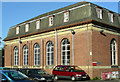
2
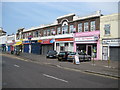
Romford: Old Mill Parade, Victoria Road
The 1881 Ordnance Survey 6" to the mile map does indeed show both a flour mill and a water mill between Victoria Road and the parallel railway behind it. As with Image which is opposite it would be interesting to know who the original occupiers of these shops were. For the record in July 2008 they are, from right to left:
T. M Nails
Belvoir Estate Agents
Feedwell Sandwich Bar
Balgores Letting Agency
Dixy Chicken
Old Mill Cafe
Image: © Nigel Cox
Taken: 27 Jul 2008
0.04 miles
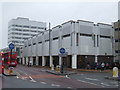
3
Brewery Shopping Centre, Romford, Essex
Another shopping centre! Built on the site of the Inde Coope Brewery.
Image: © John Winfield
Taken: 12 Jul 2005
0.06 miles
4
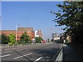
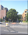
Romford Ring Road
Looking north towards Western Road
Image: © John Winfield
Taken: 31 Aug 2005
0.06 miles
5
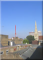
Romford Rooftops
A part of Romford town centre that is not often seen. Taken from the service road looking west.
Image: © John Winfield
Taken: 31 Aug 2005
0.06 miles
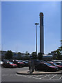
6
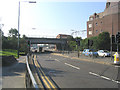
Mercury Gardens, Romford
Part of the ring road - looking south towards Victoria Road. The railway bridge is for the East Anglia-Liverpool Street lines.
Image: © John Winfield
Taken: 31 Aug 2005
0.06 miles
7
'Office City', Romford
Town planners seem to love zoning and Romford Town centre is a prime example. This shot of Eastern Road shows the area designated for offices - hence its local nickname.
Image: © John Winfield
Taken: 31 Aug 2005
0.06 miles
8
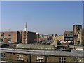
Roofs and Spires, Romford
The spire of St Edward's Church in the marketplace, seen over the roofs of nearby shops.
Image: © John Winfield
Taken: 31 Aug 2005
0.06 miles
9
Oldchurch Hospital, Romford
Oldchurch Hospital is due for closure in the next month and is likely to be demolished soon after. Many buildings date from the early part of the 20th century and this and other photographs will provide a record of this long established hospital. See Image for the new hospital.
Image: © John Winfield
Taken: 3 Nov 2006
0.06 miles
10
Chandlers Way, Romford
Chandlers Way in Romford town centre.
Image: © Malc McDonald
Taken: 2 Oct 2010
0.07 miles