IMAGES TAKEN NEAR TO
Suttons Lane, HORNCHURCH, RM12 6RT
Introduction
This page details the photographs taken nearby to Suttons Lane, RM12 6RT by members of the Geograph project.
The Geograph project started in 2005 with the aim of publishing, organising and preserving representative images for every square kilometre of Great Britain, Ireland and the Isle of Man.

There are currently over 7.5m images from over14,400 individuals and you can help contribute to the project by visiting https://www.geograph.org.uk
Image Map (Loading...)


Getting Data...Please wait
Leaflet Map data © OpenStreetMap
Images are licensed for reuse under creativecommons.org/licenses/by-sa/2.0
Notes
- Clicking on the map will re-center to the selected point.
- The higher the marker number, the further away the image location is from the centre of the postcode.
Image Listing (6 Images Found)
Images are licensed for reuse under creativecommons.org/licenses/by-sa/2.0
Image
Details
Distance
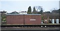
1

Building, St. George's Hospital
One of many blocks on this large site. The hospital is closed and awaits a redevelopment scheme that will satisfy the planning authority.
Image: © Robin Webster
Taken: 24 Apr 2011
0.18 miles
2
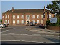
St George's Hospital
St George's is now part of Havering Hospitals NHS Trust which was established in 1993. The North East London Strategic Health Authority is considering closing the hospital. The property developers must be drooling at the prospect of a brown-field site surrounded on two sides by countryside!
Image: © Glyn Baker
Taken: 17 Aug 2005
0.18 miles
3
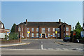
Reception block, St George's Hospital
Many of the buildings on the extensive campus appear disused and the grounds around unkempt, but not this bit.
Image: © Robin Webster
Taken: 24 Apr 2011
0.20 miles
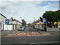
5

Petrol Station, Suttons Lane, Hornchurch
Image: © Stacey Harris
Taken: 2 Sep 2009
0.23 miles