IMAGES TAKEN NEAR TO
Highfield Road, HORNCHURCH, RM12 6PT
Introduction
This page details the photographs taken nearby to Highfield Road, RM12 6PT by members of the Geograph project.
The Geograph project started in 2005 with the aim of publishing, organising and preserving representative images for every square kilometre of Great Britain, Ireland and the Isle of Man.

There are currently over 7.5m images from over14,400 individuals and you can help contribute to the project by visiting https://www.geograph.org.uk
Image Map
Images are licensed for reuse under creativecommons.org/licenses/by-sa/2.0
Notes
- Clicking on the map will re-center to the selected point.
- The higher the marker number, the further away the image location is from the centre of the postcode.
Image Listing (70 Images Found)
Images are licensed for reuse under creativecommons.org/licenses/by-sa/2.0
Image
Details
Distance
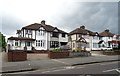
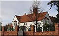
1
Highfield Rd
Highfield Rd has 1930’s style houses typical of this area
Image: © Glyn Baker
Taken: 2 Apr 2010
0.05 miles
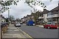
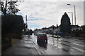
3
Upminster Road, Hornchurch
Looking south east on the A124.
Image: © JThomas
Taken: 11 May 2019
0.07 miles
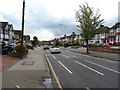
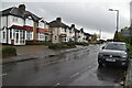
4
Newly refurbished block on Upminster Road
This was done up by Haverbridge Homes in 2018 and is now called Dury Falls Court.
Image: © David Howard
Taken: 9 Mar 2019
0.09 miles
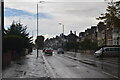

9
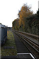
District Line Track
Looking towards Hornchurch from Upminster Bridge station. The platforms are longer than required by current services and this photo is taken from the limit of public access. The bridge in the distance carries Hacton Lane over the railway.
Image: © Martin Addison
Taken: 30 Nov 2013
0.11 miles