IMAGES TAKEN NEAR TO
Bushell Way, HORNCHURCH, RM12 6EP
Introduction
This page details the photographs taken nearby to Bushell Way, RM12 6EP by members of the Geograph project.
The Geograph project started in 2005 with the aim of publishing, organising and preserving representative images for every square kilometre of Great Britain, Ireland and the Isle of Man.

There are currently over 7.5m images from over14,400 individuals and you can help contribute to the project by visiting https://www.geograph.org.uk
Image Map
Images are licensed for reuse under creativecommons.org/licenses/by-sa/2.0
Notes
- Clicking on the map will re-center to the selected point.
- The higher the marker number, the further away the image location is from the centre of the postcode.
Image Listing (41 Images Found)
Images are licensed for reuse under creativecommons.org/licenses/by-sa/2.0
Image
Details
Distance
5
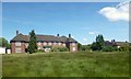
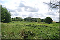
NHS.... Nice Hay Supplies?
The neglected lawns at the closed St. George's Hospital site have quickly reverted to lush meadows.
Image: © Des Blenkinsopp
Taken: 4 Jun 2013
0.11 miles
8
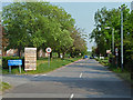
Internal road, St George's Hospital
A large campus, with an air of only being partly used. Either that, or severe economies have been made on property maintenance and grounds upkeep.
Image: © Robin Webster
Taken: 24 Apr 2011
0.11 miles
9
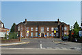
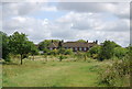
Reception block, St George's Hospital
Many of the buildings on the extensive campus appear disused and the grounds around unkempt, but not this bit.
Image: © Robin Webster
Taken: 24 Apr 2011
0.11 miles
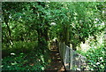
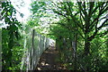
10
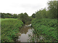
River Ingrebourne, Hacton
As seen from a footbridge in the Ingrebourne Valley Local Nature Reserve, close to Hacton Parkway.
Image: © Roger Jones
Taken: 14 Sep 2013
0.12 miles