IMAGES TAKEN NEAR TO
Hacton Drive, HORNCHURCH, RM12 6DL
Introduction
This page details the photographs taken nearby to Hacton Drive, RM12 6DL by members of the Geograph project.
The Geograph project started in 2005 with the aim of publishing, organising and preserving representative images for every square kilometre of Great Britain, Ireland and the Isle of Man.

There are currently over 7.5m images from over14,400 individuals and you can help contribute to the project by visiting https://www.geograph.org.uk
Image Map
Images are licensed for reuse under creativecommons.org/licenses/by-sa/2.0
Notes
- Clicking on the map will re-center to the selected point.
- The higher the marker number, the further away the image location is from the centre of the postcode.
Image Listing (20 Images Found)
Images are licensed for reuse under creativecommons.org/licenses/by-sa/2.0
Image
Details
Distance
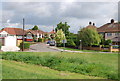
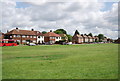
1
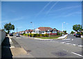
Racy Road Names
There's a bit of a racecourse thing going on here. This is Ascot Gardens and Goodwood Avenue, off Newmarket Way.
Image: © Des Blenkinsopp
Taken: 4 Jun 2013
0.11 miles
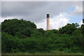
3
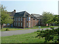
Building, St. George's Hospital
One of many blocks on this large site. The hospital is closed and awaits a redevelopment scheme that will satisfy the planning authority.
Image: © Robin Webster
Taken: 24 Apr 2011
0.15 miles
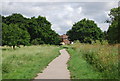
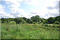
4
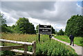
Entering the Ingrebourne Valley Local Nature Reserve
Image: © N Chadwick
Taken: 18 Jun 2011
0.17 miles
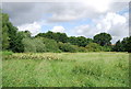
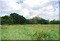
10
Ingrebourne Valley Local Nature Reserve
Image: © N Chadwick
Taken: 18 Jun 2011
0.19 miles