IMAGES TAKEN NEAR TO
Fernbank Avenue, HORNCHURCH, RM12 5RB
Introduction
This page details the photographs taken nearby to Fernbank Avenue, RM12 5RB by members of the Geograph project.
The Geograph project started in 2005 with the aim of publishing, organising and preserving representative images for every square kilometre of Great Britain, Ireland and the Isle of Man.

There are currently over 7.5m images from over14,400 individuals and you can help contribute to the project by visiting https://www.geograph.org.uk
Image Map
Images are licensed for reuse under creativecommons.org/licenses/by-sa/2.0
Notes
- Clicking on the map will re-center to the selected point.
- The higher the marker number, the further away the image location is from the centre of the postcode.
Image Listing (3 Images Found)
Images are licensed for reuse under creativecommons.org/licenses/by-sa/2.0
Image
Details
Distance

2
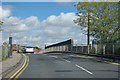
Railway bridge on Abbs Cross Lane
Over the LTSR Barking - Pitsea cut-off line and the District Line. The bridge is dual plated, FSS2 26 at the Network Rail end and D203 at the District end.
Image: © Robin Webster
Taken: 18 Sep 2011
0.18 miles
3
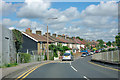
Houses on Abbs Cross Lane
Looking from the railway bridge.
Image: © Robin Webster
Taken: 18 Sep 2011
0.22 miles