IMAGES TAKEN NEAR TO
Calbourne Avenue, HORNCHURCH, RM12 5BH
Introduction
This page details the photographs taken nearby to Calbourne Avenue, RM12 5BH by members of the Geograph project.
The Geograph project started in 2005 with the aim of publishing, organising and preserving representative images for every square kilometre of Great Britain, Ireland and the Isle of Man.

There are currently over 7.5m images from over14,400 individuals and you can help contribute to the project by visiting https://www.geograph.org.uk
Image Map
Images are licensed for reuse under creativecommons.org/licenses/by-sa/2.0
Notes
- Clicking on the map will re-center to the selected point.
- The higher the marker number, the further away the image location is from the centre of the postcode.
Image Listing (8 Images Found)
Images are licensed for reuse under creativecommons.org/licenses/by-sa/2.0
Image
Details
Distance
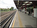
2
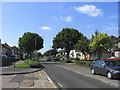
South End Road, Elm Park, Essex
Looking south from junction with Farm Way
Image: © John Winfield
Taken: 23 Aug 2005
0.21 miles
7
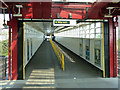
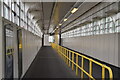
Elm Park station - access ramp
Built some time before easy access for those on wheels became a mandatory requirement.
Image: © Robin Webster
Taken: 24 Apr 2011
0.24 miles
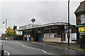
8
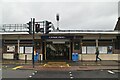
Elm Park Underground station, Greater London
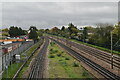
Opened in 1935 by the London Midland & Scottish Railway on the line from London to Upminster, this station transferred from British Rail to London Transport in 1969.
View south west towards Dagenham East and London. Like 55% of the London Underground network, this part is actually overground.
Image: © Nigel Thompson
Taken: 24 Sep 2015
0.25 miles