IMAGES TAKEN NEAR TO
Kenilworth Gardens, HORNCHURCH, RM12 4SE
Introduction
This page details the photographs taken nearby to Kenilworth Gardens, RM12 4SE by members of the Geograph project.
The Geograph project started in 2005 with the aim of publishing, organising and preserving representative images for every square kilometre of Great Britain, Ireland and the Isle of Man.

There are currently over 7.5m images from over14,400 individuals and you can help contribute to the project by visiting https://www.geograph.org.uk
Image Map (Loading...)


Getting Data...Please wait
Leaflet Map data © OpenStreetMap
Images are licensed for reuse under creativecommons.org/licenses/by-sa/2.0
Notes
- Clicking on the map will re-center to the selected point.
- The higher the marker number, the further away the image location is from the centre of the postcode.
Image Listing (50 Images Found)
Images are licensed for reuse under creativecommons.org/licenses/by-sa/2.0
Image
Details
Distance
3
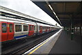
Hornchurch Underground station, Greater London
Opened in 1885 by the London Tilbury & Southend Railway on the line from London to Upminster, this station was rebuilt in 1932 when the platforms to the left were added. The LTS platforms to the right were closed in 1962. The station transferred from British Rail to London Transport in 1969.
View east towards Upminster Bridge and Upminster. Like 55% of the London Underground network, this part is actually overground.
Image: © Nigel Thompson
Taken: 24 Sep 2015
0.05 miles
4
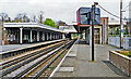
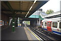
Hornchurch station
View eastward, towards Upminster: LT Underground District Line, also Southend and Shoeburyness on the ex-LT&S line from Fenchurch Street. The LT&S lines pass on the right and since 12/6/61 have not used the platforms remaining here.
Image: © Ben Brooksbank
Taken: 13 Apr 1995
0.05 miles
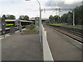
9

Hornchurch Underground station
The London, Tilbury & Southend Railway opened its line from Forest Gate via Barking and Dagenham Dock to Tilbury in 1854. In 1858 the company opened a cut off between Bow and Barking.
What is now the C2C line was opened in 1885 by the London, Tilbury & Southend Railway between Barking and Upminster, and a station was opened at Dagenham (East) the same year. No further stations opened on the line until Gale Street Halt (now Becontree) in 1926, followed by Hornchurch, Heathway (later renamed Dagenham Heathway from 1st May 1949) and Upney all on 12th September 1932. On the same date as these stations opened in 1932, the District line was extended over new tracks alongside the existing line between Barking and Upminster. The present C2C line therefore dates from 1885 and the present District line from 1932.
This view is from the up District line platform with the District lines on the left and the two C2C lines on the right beyond the fence. Upminster Bridge is the next station in this direction on the District line.
Image: © Marathon
Taken: 9 Mar 2016
0.06 miles
10
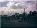
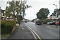
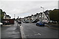
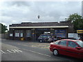
Road fork outside Hornchurch underground station
This is a response to Oxyman's Image The road layout of Suttons Lane outside Hornchurch underground station is rather unusual, as there is a small fork, with a small layby with a few parking spaces for the station on the right prong of the fork, and Suttons Lane on the left one. The abnormality of this is also reflected in the contrasting lamp standards - we have a concrete column with Philips SGS203 lantern lighting the layby and a new post-top Urbis Sapphire lantern lighting Suttons Lane mainstream. View taken looking south-southwest from Suttons Lane.
Image: © Robert Lamb
Taken: 28 Aug 2009
0.06 miles