IMAGES TAKEN NEAR TO
Willow Close, HORNCHURCH, RM12 4QR
Introduction
This page details the photographs taken nearby to Willow Close, RM12 4QR by members of the Geograph project.
The Geograph project started in 2005 with the aim of publishing, organising and preserving representative images for every square kilometre of Great Britain, Ireland and the Isle of Man.

There are currently over 7.5m images from over14,400 individuals and you can help contribute to the project by visiting https://www.geograph.org.uk
Image Map
Images are licensed for reuse under creativecommons.org/licenses/by-sa/2.0
Notes
- Clicking on the map will re-center to the selected point.
- The higher the marker number, the further away the image location is from the centre of the postcode.
Image Listing (33 Images Found)
Images are licensed for reuse under creativecommons.org/licenses/by-sa/2.0
Image
Details
Distance

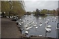
5
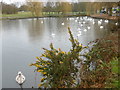
Swans on the Boating Lake in Harrow Lodge Park
Harrow Lodge Park was formally the Manor of Maylards Green and Wybridge. The original name is derived from the Mayloor family who held the manor in the 13th and 14th centuries. The Wybridge River was a tributary of the Beam River. By 1799 the estate included Wybridge as well as Maylards. In 1849 Maylards Farm consisted of 165 acres and Wybridge Farm 276 acres. Both farms survived until the Elm Park area was developed after the First World War.
The park was developed for public use in the 1900s. Some of the land was used for food production during the Second World War and after the War the Council worked to transform the park. A comprehensive plan was prepared in the late 1940s. A disused pit was filled in with waste material, and the boating lake was formed between 1954 and 1956 by damming the River Ravensbourne. A full account can be seen at http://www.londongardensonline.org.uk/gardens-online-record.asp?ID=HVG020
As can be seen the lake has a large population of swans.
Image: © Marathon
Taken: 9 Mar 2016
0.16 miles
6
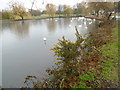
Swans on the Boating Lake in Harrow Lodge Park
Harrow Lodge Park was formally the Manor of Maylards Green and Wybridge. The original name is derived from the Mayloor family who held the manor in the 13th and 14th centuries. The Wybridge River was a tributary of the Beam River. By 1799 the estate included Wybridge as well as Maylards. In 1849 Maylards Farm consisted of 165 acres and Wybridge Farm 276 acres. Both farms survived until the Elm Park area was developed after the First World War.
The park was developed for public use in the 1900s. Some of the land was used for food production during the Second World War and after the War the Council worked to transform the park. A comprehensive plan was prepared in the late 1940s. A disused pit was filled in with waste material, and the boating lake was formed between 1954 and 1956 by damming the River Ravensbourne. A full account can be seen at http://www.londongardensonline.org.uk/gardens-online-record.asp?ID=HVG020
As can be seen the lake has a large population of swans.
Image: © Marathon
Taken: 9 Mar 2016
0.16 miles
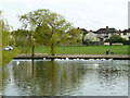
8
Harrow Lodge Park Lake
Here the River Ravensbourne feeds the boating lake in Harrow Lodge Park.
http://www.havering.gov.uk/index.aspx?articleid=4470 the lake probably couldn’t support the number of swans is does if it wasn’t for locals “feeding the ducks”
Image: © Glyn Baker
Taken: 20 Mar 2010
0.16 miles