IMAGES TAKEN NEAR TO
Upper Rainham Road, HORNCHURCH, RM12 4EY
Introduction
This page details the photographs taken nearby to Upper Rainham Road, RM12 4EY by members of the Geograph project.
The Geograph project started in 2005 with the aim of publishing, organising and preserving representative images for every square kilometre of Great Britain, Ireland and the Isle of Man.

There are currently over 7.5m images from over14,400 individuals and you can help contribute to the project by visiting https://www.geograph.org.uk
Image Map
Images are licensed for reuse under creativecommons.org/licenses/by-sa/2.0
Notes
- Clicking on the map will re-center to the selected point.
- The higher the marker number, the further away the image location is from the centre of the postcode.
Image Listing (13 Images Found)
Images are licensed for reuse under creativecommons.org/licenses/by-sa/2.0
Image
Details
Distance
1
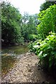
The Beam River
The Beam River is created by the confluence of the Rom and the Ravensbourne within Image nature reserve. To learn more about this London Wildlife Trust Reserve see http://www.wildlondon.org.uk/Naturereserves/TheChase/tabid/142/Default.aspx
This shot was taken looking downstream.
Image: © Glyn Baker
Taken: 20 Jun 2009
0.15 miles
2

Path alongside the River Rom in The Chase Nature Reserve
The Chase Nature Reserve was formerly a site used for gravel extraction. It now comprises a mosaic of wildlife habitats ranging from horse grazed pastures to woodland and wetland. See https://www.havering.gov.uk/Pages/ServiceChild/NatureReserves-TheChase.aspx
The River Rom, just to the right of the path here, runs through the nature reserve and here is just above its confluence with the Ravensbourne below which the River Rom is known as the Beam River. The Beam flows into the Thames at Dagenham - see https://en.wikipedia.org/wiki/River_Rom for more information.
Image: © Marathon
Taken: 4 May 2016
0.16 miles
3
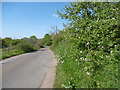
Approach road to The Chase Nature Reserve
The Chase Nature Reserve was formerly a site used for gravel extraction. It now comprises a mosaic of wildlife habitats ranging from horse grazed pastures to woodland and wetland. See https://www.havering.gov.uk/Pages/ServiceChild/NatureReserves-TheChase.aspx
The River Rom, which is crossed a little way ahead, runs through the nature reserve and here is just above its confluence with the Ravensbourne below which the River Rom is known as the Beam River. The Beam flows into the Thames at Dagenham - see https://en.wikipedia.org/wiki/River_Rom for more information.
This lane leads off Upper Rainham Road (A125) and passes horse riding facilities and reaches the Millennium Centre for the Reserve.
Image: © Marathon
Taken: 4 May 2016
0.17 miles
4
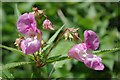
Himalayan balsam
This Impatiens glandulifera was growing by Image Indian balsam was introduced from the Himalayas it has become naturalised to British river banks and damp ground.
Image: © Glyn Baker
Taken: 20 Jun 2009
0.18 miles
5

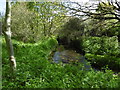
River Rom flowing through The Chase Nature Reserve
The Chase Nature Reserve was formerly a site used for gravel extraction. It now comprises a mosaic of wildlife habitats ranging from horse grazed pastures to woodland and wetland. See https://www.havering.gov.uk/Pages/ServiceChild/NatureReserves-TheChase.aspx
The River Rom runs through the nature reserve and here is just above its confluence with the Ravensbourne below which the River Rom is known as the Beam River. The Beam flows into the Thames at Dagenham - see https://en.wikipedia.org/wiki/River_Rom for more information.
Image: © Marathon
Taken: 4 May 2016
0.19 miles
6
River Rom flowing through The Chase Nature Reserve
The Chase Nature Reserve was formerly a site used for gravel extraction. It now comprises a mosaic of wildlife habitats ranging from horse grazed pastures to woodland and wetland. See https://www.havering.gov.uk/Pages/ServiceChild/NatureReserves-TheChase.aspx
The River Rom runs through the nature reserve and here is just above its confluence with the Ravensbourne below which the River Rom is known as the Beam River. The Beam flows into the Thames at Dagenham - see https://en.wikipedia.org/wiki/River_Rom for more information.
Image: © Marathon
Taken: 4 May 2016
0.19 miles
7
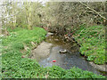
River Rom
In The Chase Local Nature Reserve, just above the bridge for The Chase. This might be still called the Beam River, its name lower down. But this is above the confluence with the Ravensbourne, so let's call it Rom.
Image: © Robin Webster
Taken: 2 Apr 2011
0.19 miles
8

Blackthorn in bloom, The Chase Local Nature Reserve
Image: © Robin Webster
Taken: 2 Apr 2011
0.20 miles
9

The Chase bridge over River Rom
This might be still called the Beam River, its name lower down. But this is above the confluence with the Ravensbourne, so let's call it Rom. There are old flood arches to the right, looking rather buried viewed from the other side. They look as if they predate the current generous main span.
Image: © Robin Webster
Taken: 2 Apr 2011
0.21 miles
10

River Rom below The Chase bridge
This might be still called the Beam River, its name lower down. But this is above the confluence with the Ravensbourne, so let's call it Rom.
Image: © Robin Webster
Taken: 2 Apr 2011
0.22 miles