IMAGES TAKEN NEAR TO
Carfax Road, HORNCHURCH, RM12 4BA
Introduction
This page details the photographs taken nearby to Carfax Road, RM12 4BA by members of the Geograph project.
The Geograph project started in 2005 with the aim of publishing, organising and preserving representative images for every square kilometre of Great Britain, Ireland and the Isle of Man.

There are currently over 7.5m images from over14,400 individuals and you can help contribute to the project by visiting https://www.geograph.org.uk
Image Map (Loading...)


Getting Data...Please wait
Leaflet Map data © OpenStreetMap
Images are licensed for reuse under creativecommons.org/licenses/by-sa/2.0
Notes
- Clicking on the map will re-center to the selected point.
- The higher the marker number, the further away the image location is from the centre of the postcode.
Image Listing (34 Images Found)
Images are licensed for reuse under creativecommons.org/licenses/by-sa/2.0
Image
Details
Distance
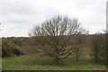
8
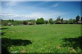
The Last Bit of Green
This small corner of Harrow Lodge Park http://www.havering.gov.uk/index.aspx?articleid=4470 is just about the only bit of green space in Image the rest is almost entirely built over.
Image: © Glyn Baker
Taken: 6 May 2010
0.11 miles
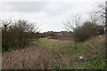
9
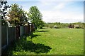
Harrow Lodge Park in Elm Park
These fences back on to Image in Elm Park.
Image: © Glyn Baker
Taken: 6 May 2010
0.12 miles