IMAGES TAKEN NEAR TO
Logan Mews, ROMFORD, RM1 1LN
Introduction
This page details the photographs taken nearby to Logan Mews, RM1 1LN by members of the Geograph project.
The Geograph project started in 2005 with the aim of publishing, organising and preserving representative images for every square kilometre of Great Britain, Ireland and the Isle of Man.

There are currently over 7.5m images from over14,400 individuals and you can help contribute to the project by visiting https://www.geograph.org.uk
Image Map
Images are licensed for reuse under creativecommons.org/licenses/by-sa/2.0
Notes
- Clicking on the map will re-center to the selected point.
- The higher the marker number, the further away the image location is from the centre of the postcode.
Image Listing (194 Images Found)
Images are licensed for reuse under creativecommons.org/licenses/by-sa/2.0
Image
Details
Distance
1
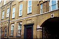
Former Romford Brewery building
Romford Brewery closed in 1993, and most of the site was demolished and replaced with the Brewery shopping centre which opened in 2001. Some parts of the old brewery have survived, as shown here. Part of the building now serves as the Havering Museum, and much of the remainder has been converted into housing.
Image: © Richard Winch
Taken: 5 Jun 2017
0.02 miles
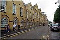
3
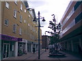
Brewery Walk, Romford
Here is a view of Brewery Walk, a pleasant paved pedestrianised (there's a great piece of alliteration!) alley linking the Brewery car park and shops with the pedestrianised town centre thoroughfare. It is tree-lined down the middle and has circular benches which completely enclose the trees. It is also lit with some rather posh-looking lamp posts. I frequently stop here to eat my lunch (usually bought from nearby Greggs or Subway) when I come shopping here with my friends. I am, however, unsure if I have got the geographical location right - Romford town centre is so complex and full of paths and alleys, I just don't know exactly which alley on the OS map is Brewery Walk!
Image: © Robert Lamb
Taken: 19 Aug 2008
0.04 miles
4
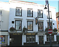
The Golden Lion, Romford
The old inn is situated at the western end of Romford Market.
Image: © John Winfield
Taken: 3 Nov 2006
0.04 miles
5
Christmas tree and some more tinsel decorations
An even more spectacular sight here of those tinsel decorations, complete with Christmas tree! Note how the decorations in the background follow a neat line along the roof, creating a rather pretty and appealing bit of decoration! View taken looking out towards the marketplace.
Image: © Robert Lamb
Taken: 21 Nov 2009
0.04 miles
6
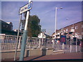
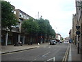
High Street, Romford
Angel Way begins as High Street at its junction with St Edwards Way - it doesn't become Angel Way until you reach the road barrier on the High Street and you turn the corner to get into the multi-storey car park. View taken looking northeast towards the town centre from St Edwards Way.
Image: © Robert Lamb
Taken: 10 Oct 2008
0.05 miles
7
Romford: Salvation Army Citadel
The church in the High Street is currently closed while a major refurbishment is undertaken.
Image: © Nigel Cox
Taken: 27 Jul 2008
0.05 miles
8
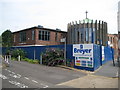
Havering Museum
The Museum http://www.haveringmuseum.org.uk/ is housed in the former Romford Brewery (Ind Coope [Allied Breweries]). From the mid twentieth century this Victorian Brewery was used as offices for a huge beer factory now replaced by a shopping mall.
Image: © Glyn Baker
Taken: 3 Jul 2012
0.05 miles
9
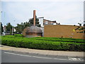
Romford: Former Romford Brewery tun
The plaque in front of the tun reads:-
"This original copper brewing tun was part of the former Romford Brewery which ceased production in February 1993. It was donated by the London Borough of Havering to Romford Developments Limited, a joint venture between Stannifer and J Sainsbury Developments Limited. The tun was unveiled in the Spring of 2001, to mark the opening of the new Brewery Development, which was designed by Architects Chetwood Associates."
Image: © Nigel Cox
Taken: 27 Jul 2008
0.05 miles