IMAGES TAKEN NEAR TO
Burnway, HORNCHURCH, RM11 3SG
Introduction
This page details the photographs taken nearby to Burnway, RM11 3SG by members of the Geograph project.
The Geograph project started in 2005 with the aim of publishing, organising and preserving representative images for every square kilometre of Great Britain, Ireland and the Isle of Man.

There are currently over 7.5m images from over14,400 individuals and you can help contribute to the project by visiting https://www.geograph.org.uk
Image Map
Images are licensed for reuse under creativecommons.org/licenses/by-sa/2.0
Notes
- Clicking on the map will re-center to the selected point.
- The higher the marker number, the further away the image location is from the centre of the postcode.
Image Listing (35 Images Found)
Images are licensed for reuse under creativecommons.org/licenses/by-sa/2.0
Image
Details
Distance
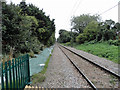
1
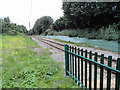
Romford to Upminster line facing towards Romford
Taken from the crossing on footpath 170.
Image: © Phil Gaskin
Taken: 4 Sep 2015
0.08 miles
2
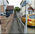
Entrance to footpath 170 in Burnway
Footpath 170 leads to Beverley Gardens via Maybush Road.
Image: © Phil Gaskin
Taken: 4 Sep 2015
0.08 miles
3
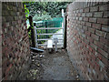
Path 170 close to the railway
Path 170 crosses the Romford to Upminster line.
Image: © Phil Gaskin
Taken: 4 Sep 2015
0.08 miles
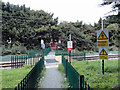
4
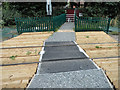
Refurbished crossing on the Romford to Upminster line
On footpath 170 from Burnway to Beverley Gardens.
Image: © Phil Gaskin
Taken: 4 Sep 2015
0.09 miles
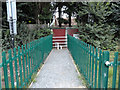
5
Footpath 170 crosses the railway
Footpath crossing the Romford to Upminster line from the Burnway side.
Image: © Phil Gaskin
Taken: 4 Sep 2015
0.09 miles
6
Footpath 170 on the Beverley Gardens side of the railway crossing
Footpath 170 crosses the Romford to Upminster line.
Image: © Phil Gaskin
Taken: 4 Sep 2015
0.10 miles
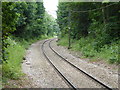
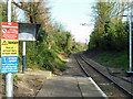
7
The Romford to Upminster line towards Upminster
Taken from the crossing on footpath 170 between Beverley Gardens and Burnway.
Image: © Phil Gaskin
Taken: 4 Sep 2015
0.10 miles
8
Looking towards Upminster from Emerson Park station
The Romford to Upminster Line was constructed in 1893 as a branch of the London, Tilbury & Southend Railway from Upminster. This opened on 7th June 1893 at a second station in Romford which was combined with the main station at Romford in 1934. Emerson Park station was opened on 1st October 1909 as Emerson Park Halt. A video about the line can be seen at https://www.youtube.com/watch?v=_TwuKTthbTU
The half hourly London Overground train from Romford to Upminster has just left from the single bi-directional platform and disappeared round the corner ahead.
Image: © Marathon
Taken: 7 Jun 2017
0.13 miles
9
Platform end, Emerson Park Halt
Looking towards Upminster on this single track branch. It is operated by a single manned single unit, shuttling backwards and forwards from Romford to Upminster. As these are not far apart, a reasonably frequent service results.
Image: © Robin Webster
Taken: 9 Apr 2011
0.13 miles
10

Footpath 170 heading towards Maybush Road
Just after the Romford to Upminster line railway crossing.
Image: © Phil Gaskin
Taken: 4 Sep 2015
0.13 miles