IMAGES TAKEN NEAR TO
Hedingham Road, HORNCHURCH, RM11 3QH
Introduction
This page details the photographs taken nearby to Hedingham Road, RM11 3QH by members of the Geograph project.
The Geograph project started in 2005 with the aim of publishing, organising and preserving representative images for every square kilometre of Great Britain, Ireland and the Isle of Man.

There are currently over 7.5m images from over14,400 individuals and you can help contribute to the project by visiting https://www.geograph.org.uk
Image Map
Images are licensed for reuse under creativecommons.org/licenses/by-sa/2.0
Notes
- Clicking on the map will re-center to the selected point.
- The higher the marker number, the further away the image location is from the centre of the postcode.
Image Listing (39 Images Found)
Images are licensed for reuse under creativecommons.org/licenses/by-sa/2.0
Image
Details
Distance
2
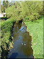
Two drakes on the Ingrebourne
Viewed from the Berkeley Drive bridge.
Image: © Robin Webster
Taken: 9 Apr 2011
0.14 miles
4
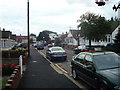
Track behind houses on Benets Road
Giving access to back garden garages, among other things.
Image: © Robin Webster
Taken: 9 Apr 2011
0.14 miles
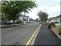
5
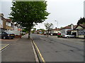
Minster Way, Hornchurch
Looking north west.
Image: © JThomas
Taken: 11 May 2019
0.15 miles
6
Behind the houses, Benets Road
The houses are to the left.
Image: © Robin Webster
Taken: 9 Apr 2011
0.15 miles
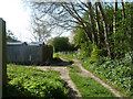
10
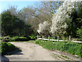
Former route of the London LOOP
The London LOOP, north of Upminster Bridge station formerly ran along the back of the houses in Wingletye Lane before passing through a small wood to briefly run along Wingletye Lane. It now turns right here and passes nearly half a mile east of its former route, close to the Ingrebourne River. It is still a footpath ahead but without the significance of being part of the LOOP.
Image: © Marathon
Taken: 14 Jun 2017
0.22 miles