IMAGES TAKEN NEAR TO
Hubbards Chase, HORNCHURCH, RM11 3DD
Introduction
This page details the photographs taken nearby to Hubbards Chase, RM11 3DD by members of the Geograph project.
The Geograph project started in 2005 with the aim of publishing, organising and preserving representative images for every square kilometre of Great Britain, Ireland and the Isle of Man.

There are currently over 7.5m images from over14,400 individuals and you can help contribute to the project by visiting https://www.geograph.org.uk
Image Map
Images are licensed for reuse under creativecommons.org/licenses/by-sa/2.0
Notes
- Clicking on the map will re-center to the selected point.
- The higher the marker number, the further away the image location is from the centre of the postcode.
Image Listing (6 Images Found)
Images are licensed for reuse under creativecommons.org/licenses/by-sa/2.0
Image
Details
Distance
3
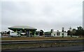
Service station on Southend Arterial Road (A127)
Image: © JThomas
Taken: 23 Aug 2022
0.21 miles
4
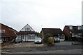
Nelwin Avenue
Some small houses (by Emerson Park Standards!)
Image: © Glyn Baker
Taken: 2 Dec 2012
0.22 miles
5
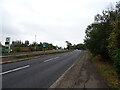
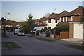
Southend Arterial Road (A127)
Eastbound towards the M25 Motorway.
Image: © JThomas
Taken: 23 Aug 2022
0.24 miles
6
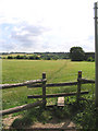
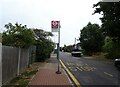
Footpath, off Wingletye Lane, Hornchurch, Essex
Designated footpath running east from Wych Elm Road to Hall lane Upminster.
Image: © John Winfield
Taken: 5 Jul 2005
0.24 miles