IMAGES TAKEN NEAR TO
Southend Arterial Road, HORNCHURCH, RM11 2SE
Introduction
This page details the photographs taken nearby to Southend Arterial Road, RM11 2SE by members of the Geograph project.
The Geograph project started in 2005 with the aim of publishing, organising and preserving representative images for every square kilometre of Great Britain, Ireland and the Isle of Man.

There are currently over 7.5m images from over14,400 individuals and you can help contribute to the project by visiting https://www.geograph.org.uk
Image Map
Images are licensed for reuse under creativecommons.org/licenses/by-sa/2.0
Notes
- Clicking on the map will re-center to the selected point.
- The higher the marker number, the further away the image location is from the centre of the postcode.
Image Listing (7 Images Found)
Images are licensed for reuse under creativecommons.org/licenses/by-sa/2.0
Image
Details
Distance
1
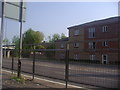
Bridge Point on Eastern Avenue, Harold Wood
Image: © David Howard
Taken: 24 May 2012
0.05 miles
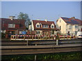
3
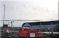
Roadworks on the A127, Harold Wood
Whatever they're doing they've been making a mess for a long time.
Image: © David Howard
Taken: 9 Mar 2019
0.13 miles
4
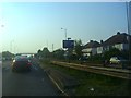
Eastern Avenue approaching Squirrels Heath Road
Image: © David Howard
Taken: 24 May 2012
0.17 miles
6
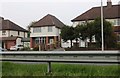
Houses on Eastern Avenue East, Harold Wood
Image: © David Howard
Taken: 8 Apr 2019
0.23 miles
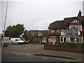
7
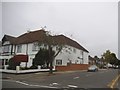
Rosslyn Avenue, Harold Wood
Abbeleigh House care home is on the left.
Image: © David Howard
Taken: 3 Sep 2017
0.23 miles