IMAGES TAKEN NEAR TO
Brookside, HORNCHURCH, RM11 2RR
Introduction
This page details the photographs taken nearby to Brookside, RM11 2RR by members of the Geograph project.
The Geograph project started in 2005 with the aim of publishing, organising and preserving representative images for every square kilometre of Great Britain, Ireland and the Isle of Man.

There are currently over 7.5m images from over14,400 individuals and you can help contribute to the project by visiting https://www.geograph.org.uk
Image Map
Images are licensed for reuse under creativecommons.org/licenses/by-sa/2.0
Notes
- Clicking on the map will re-center to the selected point.
- The higher the marker number, the further away the image location is from the centre of the postcode.
Image Listing (4 Images Found)
Images are licensed for reuse under creativecommons.org/licenses/by-sa/2.0
Image
Details
Distance
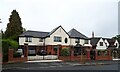

3

Nelmes Way, Ardleigh Green
The majority of the houses in Nelmes Way are large and detached and the roads are tree-lined. This is on the corner of Garland Way.
Image: © Marathon
Taken: 26 Jul 2017
0.21 miles
4

Woodlands Avenue, Emerson Park
Autumn in the fashionable part of Romford.
Image: © John Myers
Taken: 17 Nov 2006
0.21 miles