IMAGES TAKEN NEAR TO
Birch Crescent, HORNCHURCH, RM11 2NN
Introduction
This page details the photographs taken nearby to Birch Crescent, RM11 2NN by members of the Geograph project.
The Geograph project started in 2005 with the aim of publishing, organising and preserving representative images for every square kilometre of Great Britain, Ireland and the Isle of Man.

There are currently over 7.5m images from over14,400 individuals and you can help contribute to the project by visiting https://www.geograph.org.uk
Image Map (Loading...)


Getting Data...Please wait
Leaflet Map data © OpenStreetMap
Images are licensed for reuse under creativecommons.org/licenses/by-sa/2.0
Notes
- Clicking on the map will re-center to the selected point.
- The higher the marker number, the further away the image location is from the centre of the postcode.
Image Listing (37 Images Found)
Images are licensed for reuse under creativecommons.org/licenses/by-sa/2.0
Image
Details
Distance
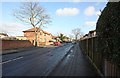
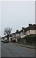
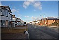
2
Harwood Avenue at the junction of Cecil Avenue
Image: © David Howard
Taken: 26 Dec 2024
0.07 miles
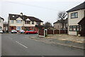
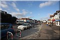
3
Cecil Ave
Gathering dusk at 15:00hrs December is truly here
Image: © Glyn Baker
Taken: 2 Dec 2012
0.09 miles
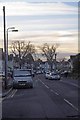
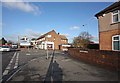
5
Cecil Avenue, Ardleigh Green
This is typical of the early 1930s roads of what was west Essex at the time, and go from Wanstead to Upminster with very little variation. My father's family lived in one from when it was built in 1933.
Image: © David Howard
Taken: 26 Dec 2024
0.10 miles
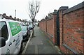
6
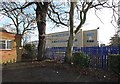
Havering College of Further & Higher Education
Image: © John Salmon
Taken: 26 Jan 2009
0.10 miles
10
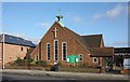
All Saints, Ardleigh Green Road, Squirrels Heath
Image: © John Salmon
Taken: 26 Jan 2009
0.11 miles