IMAGES TAKEN NEAR TO
Wootton Close, HORNCHURCH, RM11 2JU
Introduction
This page details the photographs taken nearby to Wootton Close, RM11 2JU by members of the Geograph project.
The Geograph project started in 2005 with the aim of publishing, organising and preserving representative images for every square kilometre of Great Britain, Ireland and the Isle of Man.

There are currently over 7.5m images from over14,400 individuals and you can help contribute to the project by visiting https://www.geograph.org.uk
Image Map
Images are licensed for reuse under creativecommons.org/licenses/by-sa/2.0
Notes
- Clicking on the map will re-center to the selected point.
- The higher the marker number, the further away the image location is from the centre of the postcode.
Image Listing (8 Images Found)
Images are licensed for reuse under creativecommons.org/licenses/by-sa/2.0
Image
Details
Distance
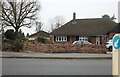
1
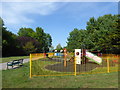
The playground in Haynes Park
The first mention of the word 'Haynes' in the area is in 1492 in a document in New College, Oxford. The "Farmhouse called Haynes" is recorded in 1692. One of the last owners was a Mr A S Wilkin who was an early director of the Tiptree Jam & Britannia Fruit Preserving Company. From time to time fruit was supplied from the farm to Tiptree.
In June 1935 it was reported to Hornchurch Urban District Council that a portion of the land had been sold and the remainder was on the market "for a price that was not unreasonable". However, a price could not be agreed and the land was compulsorily purchased. The park received much of its present layout in the 1940s and in 1963 a further three acres were added which had been part of Haynes Park Farm owned by Mrs Wilkin.
Image: © Marathon
Taken: 10 May 2017
0.14 miles
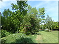
2
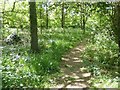
Woodland path in Haynes Park
The first mention of the word 'Haynes' in the area is in 1492 in a document in New College, Oxford. The "Farmhouse called Haynes" is recorded in 1692. One of the last owners was a Mr A S Wilkin who was an early director of the Tiptree Jam & Britannia Fruit Preserving Company. From time to time fruit was supplied from the farm to Tiptree.
In June 1935 it was reported to Hornchurch Urban District Council that a portion of the land had been sold and the remainder was on the market "for a price that was not unreasonable". However, a price could not be agreed and the land was compulsorily purchased. The park received much of its present layout in the 1940s and in 1963 a further three acres were added which had been part of Haynes Park Farm owned by Mrs Wilkin.
There is an area of woodland in Haynes Park, where this path is seen, as well as a Conservation Area.
Image: © Marathon
Taken: 14 May 2017
0.16 miles
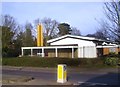
3
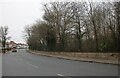
Haynes Park
A recreation Ground between Ardleigh Green and Heath Park
Image: © Glyn Baker
Taken: 10 Apr 2012
0.19 miles
5
Haynes Park
The first mention of the word 'Haynes' in the area is in 1492 in a document in New College, Oxford. The "Farmhouse called Haynes" is recorded in 1692. One of the last owners was a Mr A S Wilkin who was an early director of the Tiptree Jam & Britannia Fruit Preserving Company. From time to time fruit was supplied from the farm to Tiptree.
In June 1935 it was reported to Hornchurch Urban District Council that a portion of the land had been sold and the remainder was on the market "for a price that was not unreasonable". However, a price could not be agreed and the land was compulsorily purchased. The park received much of its present layout in the 1940s and in 1963 a further three acres were added which had been part of Haynes Park Farm owned by Mrs Wilkin.
There is an area of woodland in Haynes Park, which is seen on the left here, as well as a Conservation Area.
Image: © Marathon
Taken: 10 May 2017
0.20 miles
7
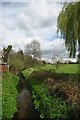
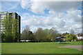
The Ravensbourne in Haynes Park
Haynes Park is an urban lung between Ardleigh Green and Heath Park
Image: © Glyn Baker
Taken: 10 Apr 2012
0.22 miles