IMAGES TAKEN NEAR TO
Cobill Close, HORNCHURCH, RM11 2DU
Introduction
This page details the photographs taken nearby to Cobill Close, RM11 2DU by members of the Geograph project.
The Geograph project started in 2005 with the aim of publishing, organising and preserving representative images for every square kilometre of Great Britain, Ireland and the Isle of Man.

There are currently over 7.5m images from over14,400 individuals and you can help contribute to the project by visiting https://www.geograph.org.uk
Image Map (Loading...)


Getting Data...Please wait
Leaflet Map data © OpenStreetMap
Images are licensed for reuse under creativecommons.org/licenses/by-sa/2.0
Notes
- Clicking on the map will re-center to the selected point.
- The higher the marker number, the further away the image location is from the centre of the postcode.
Image Listing (26 Images Found)
Images are licensed for reuse under creativecommons.org/licenses/by-sa/2.0
Image
Details
Distance
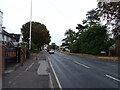
4
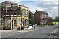
The New Inn, Squirrels Heath Lane
I've seen this before, a pub called The New Inn is actually the oldest building in the neighbourhood.
Now completely at odds with its surroundings, The New Inn is still in business on Squirrels Heath Lane, a road name that also sounds like it was here long before tower blocks were invented.
Image: © Des Blenkinsopp
Taken: 17 Jul 2024
0.14 miles
5
The New Inn
The New Inn sports faded Taylor Walker Livery from the 1980's. It stands on Squirrels Heath Lane at the junction with Westmoreland Ave (foreground) and Elvet Ave
Image: © Glyn Baker
Taken: 10 Apr 2012
0.15 miles
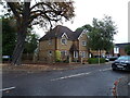
6
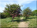
Path through the Conservation Area in Haynes Park
The first mention of the word 'Haynes' in the area is in 1492 in a document in New College, Oxford. The "Farmhouse called Haynes" is recorded in 1692. One of the last owners was a Mr A S Wilkin who was an early director of the Tiptree Jam & Britannia Fruit Preserving Company. From time to time fruit was supplied from the farm to Tiptree.
In June 1935 it was reported to Hornchurch Urban District Council that a portion of the land had been sold and the remainder was on the market "for a price that was not unreasonable". However, a price could not be agreed and the land was compulsorily purchased. The park received much of its present layout in the 1940s and in 1963 a further three acres were added which had been part of Haynes Park Farm owned by Mrs Wilkin.
There is an area of woodland in Haynes Park, as well as a Conservation Area in the northern half of the park which is seen here.
Image: © Marathon
Taken: 10 May 2017
0.17 miles
7
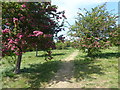
Conservation Area in Haynes Park
The first mention of the word 'Haynes' in the area is in 1492 in a document in New College, Oxford. The "Farmhouse called Haynes" is recorded in 1692. One of the last owners was a Mr A S Wilkin who was an early director of the Tiptree Jam & Britannia Fruit Preserving Company. From time to time fruit was supplied from the farm to Tiptree.
In June 1935 it was reported to Hornchurch Urban District Council that a portion of the land had been sold and the remainder was on the market "for a price that was not unreasonable". However, a price could not be agreed and the land was compulsorily purchased. The park received much of its present layout in the 1940s and in 1963 a further three acres were added which had been part of Haynes Park Farm owned by Mrs Wilkin.
There is an area of woodland in Haynes Park, as well as a Conservation Area in the northern half of the park which is seen here.
Image: © Marathon
Taken: 10 May 2017
0.17 miles
8
Path through the Conservation Area in Haynes Park
The first mention of the word 'Haynes' in the area is in 1492 in a document in New College, Oxford. The "Farmhouse called Haynes" is recorded in 1692. One of the last owners was a Mr A S Wilkin who was an early director of the Tiptree Jam & Britannia Fruit Preserving Company. From time to time fruit was supplied from the farm to Tiptree.
In June 1935 it was reported to Hornchurch Urban District Council that a portion of the land had been sold and the remainder was on the market "for a price that was not unreasonable". However, a price could not be agreed and the land was compulsorily purchased. The park received much of its present layout in the 1940s and in 1963 a further three acres were added which had been part of Haynes Park Farm owned by Mrs Wilkin.
There is an area of woodland in Haynes Park, as well as a Conservation Area in the northern half of the park which is seen here.
Image: © Marathon
Taken: 10 May 2017
0.17 miles
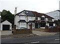
9
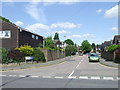
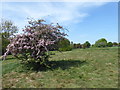
Mulberry Close, Gidea Park
Mulberry Close is a residential cul-de-sac in Gidea Park, in London's outer suburbs.
Image: © Malc McDonald
Taken: 25 May 2013
0.18 miles
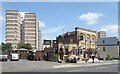
10
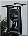
Sign for the Drill, Romford
See Image] for context.
Image: © JThomas
Taken: 23 Aug 2022
0.19 miles