IMAGES TAKEN NEAR TO
Bush Elms Road, HORNCHURCH, RM11 1LS
Introduction
This page details the photographs taken nearby to Bush Elms Road, RM11 1LS by members of the Geograph project.
The Geograph project started in 2005 with the aim of publishing, organising and preserving representative images for every square kilometre of Great Britain, Ireland and the Isle of Man.

There are currently over 7.5m images from over14,400 individuals and you can help contribute to the project by visiting https://www.geograph.org.uk
Image Map
Images are licensed for reuse under creativecommons.org/licenses/by-sa/2.0
Notes
- Clicking on the map will re-center to the selected point.
- The higher the marker number, the further away the image location is from the centre of the postcode.
Image Listing (25 Images Found)
Images are licensed for reuse under creativecommons.org/licenses/by-sa/2.0
Image
Details
Distance
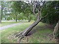
1
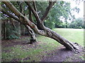
Stunted trees in Hylands Park
In 1812 the area of land that was to become Hylands Park was agricultural land. The land was bought in 1920 by a family named French who owned the Oak Public House in Victoria Road, Romford. They originally used the land for grazing and as a piggery and it also contained an orchard. In 1925 a large trotting track was laid out which included a track, stands, stables and other facilities. Hornchurch Urban District Council purchased the land in early 1927 and they then developed the public park which became Hylands Park.
The trotting track was on occasions used for athletics meetings. Temporary horse stalls were built along the large oval earth track which was also slightly banked to help with the drainage and to help control the trotting buggies. Each race commenced with a rolling start where the horses completed one lap of the quarter mile track and at the drop of a flag they completed a further four laps. The first race meeting was held on Whit Monday 1925 and was attended by a large crowd. The meetings were widely publicised and the owners of trotting horses came from all over the country. What was the trotting track is now the oval path in the eastern part of the park.
This photograph is in the south-west corner of the park which just creeps into square TQ5287.
Image: © Marathon
Taken: 28 Jun 2017
0.15 miles
2
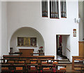
Holy Cross, Hornchurch Road, Hornchurch - Chapel
Image: © John Salmon
Taken: 2 Mar 2005
0.16 miles
3
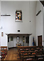
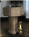
Holy Cross, Hornchurch Road, Hornchurch - Baptistry
Image: © John Salmon
Taken: 2 Mar 2005
0.16 miles
4
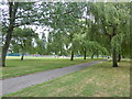
Hylands Park
In 1812 the area of land that was to become Hylands Park was agricultural land. The land was bought in 1920 by a family named French who owned the Oak Public House in Victoria Road, Romford. They originally used the land for grazing and as a piggery and it also contained an orchard. In 1925 a large trotting track was laid out which included a track, stands, stables and other facilities. Hornchurch Urban District Council purchased the land in early 1927 and they then developed the public park which became Hylands Park.
The trotting track was on occasions used for athletics meetings. Temporary horse stalls were built along the large oval earth track which was also slightly banked to help with the drainage and to help control the trotting buggies. Each race commenced with a rolling start where the horses completed one lap of the quarter mile track and at the drop of a flag they completed a further four laps. The first race meeting was held on Whit Monday 1925 and was attended by a large crowd. The meetings were widely publicised and the owners of trotting horses came from all over the country. What was the trotting track is now the oval path in the eastern part of the park.
This photograph is in the south-west corner of the park which just creeps into square TQ5287.
Image: © Marathon
Taken: 28 Jun 2017
0.16 miles
5
Stunted tree in Hylands Park
In 1812 the area of land that was to become Hylands Park was agricultural land. The land was bought in 1920 by a family named French who owned the Oak Public House in Victoria Road, Romford. They originally used the land for grazing and as a piggery and it also contained an orchard. In 1925 a large trotting track was laid out which included a track, stands, stables and other facilities. Hornchurch Urban District Council purchased the land in early 1927 and they then developed the public park which became Hylands Park.
The trotting track was on occasions used for athletics meetings. Temporary horse stalls were built along the large oval earth track which was also slightly banked to help with the drainage and to help control the trotting buggies. Each race commenced with a rolling start where the horses completed one lap of the quarter mile track and at the drop of a flag they completed a further four laps. The first race meeting was held on Whit Monday 1925 and was attended by a large crowd. The meetings were widely publicised and the owners of trotting horses came from all over the country. What was the trotting track is now the oval path in the eastern part of the park.
This photograph is in the south-west corner of the park which just creeps into square TQ5287. See also http://www.geograph.org.uk/photo/5443948
Image: © Marathon
Taken: 28 Jun 2017
0.16 miles
6
Holy Cross, Hornchurch Road, Hornchurch - Font
Image: © John Salmon
Taken: 2 Mar 2005
0.17 miles
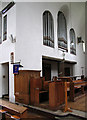
7

Holy Cross, Hornchurch Road, Hornchurch - Interior
Towards baptistry
Image: © John Salmon
Taken: 2 Mar 2005
0.17 miles
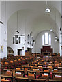
8
Holy Cross, Hornchurch Road, Hornchurch - Chancel
Image: © John Salmon
Taken: 2 Mar 2005
0.17 miles
9
Holy Cross, Hornchurch Road, Hornchurch - East end
Image: © John Salmon
Taken: 2 Mar 2005
0.17 miles
10
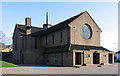
Holy Cross, Hornchurch Road, Hornchurch
Image: © John Salmon
Taken: 15 Feb 2005
0.17 miles