IMAGES TAKEN NEAR TO
Allandale Road, HORNCHURCH, RM11 1AP
Introduction
This page details the photographs taken nearby to Allandale Road, RM11 1AP by members of the Geograph project.
The Geograph project started in 2005 with the aim of publishing, organising and preserving representative images for every square kilometre of Great Britain, Ireland and the Isle of Man.

There are currently over 7.5m images from over14,400 individuals and you can help contribute to the project by visiting https://www.geograph.org.uk
Image Map
Images are licensed for reuse under creativecommons.org/licenses/by-sa/2.0
Notes
- Clicking on the map will re-center to the selected point.
- The higher the marker number, the further away the image location is from the centre of the postcode.
Image Listing (3 Images Found)
Images are licensed for reuse under creativecommons.org/licenses/by-sa/2.0
Image
Details
Distance
1
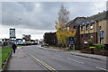
South Street, Romford
Looking south from the corner of Dymoke Road.
Image: © Trevor Harris
Taken: 22 Oct 2020
0.19 miles
2
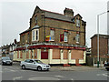
The Old Oak - another closed pub
It does not seem to be a permanent closure - yet. The "To Let" sign says it is to be let as a pub business.
Image: © Robin Webster
Taken: 2 Apr 2011
0.23 miles
3
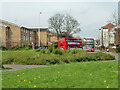
Buses on South Street, Romford, 2011
The green area at Roneo Corner has since been built on.
Image: © Robin Webster
Taken: 2 Apr 2011
0.25 miles