IMAGES TAKEN NEAR TO
St. Giles Avenue, DAGENHAM, RM10 9TB
Introduction
This page details the photographs taken nearby to St. Giles Avenue, RM10 9TB by members of the Geograph project.
The Geograph project started in 2005 with the aim of publishing, organising and preserving representative images for every square kilometre of Great Britain, Ireland and the Isle of Man.

There are currently over 7.5m images from over14,400 individuals and you can help contribute to the project by visiting https://www.geograph.org.uk
Image Map
Images are licensed for reuse under creativecommons.org/licenses/by-sa/2.0
Notes
- Clicking on the map will re-center to the selected point.
- The higher the marker number, the further away the image location is from the centre of the postcode.
Image Listing (86 Images Found)
Images are licensed for reuse under creativecommons.org/licenses/by-sa/2.0
Image
Details
Distance
1
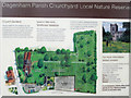
Information board and outline map, Dagenham Parish Churchyard
Image: © Roger Jones
Taken: 25 Jul 2015
0.04 miles
2
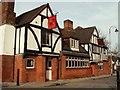
'Cross Keys' inn
This building dates back to 1500, but records of it being an inn only go back to the year 1708 when it was known as the Queens Head. The building was badly damaged by fire in the 1990's and had to have a complete new roof. The inn stands next to the parish church.
Image: © Robert Edwards
Taken: 14 Feb 2007
0.05 miles
3
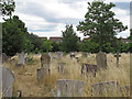
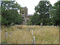
"God's Little Acre" Dagenham Parish Churchyard
Image: © Roger Jones
Taken: 25 Jul 2015
0.06 miles
4
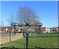
NEW
Dagenham Village Sign
A sign beside the churchyard wall is a reminder that Dagenham was an old village long before the 20th century swallowed it up.
Image: © Des Blenkinsopp
Taken: 3 Mar 2025
0.06 miles
5
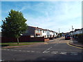
Brook Avenue, Dagenham
Brook Avenue in Dagenham, in the outer suburbs of east London.
Image: © Malc McDonald
Taken: 28 Aug 2017
0.06 miles
6
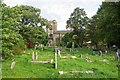
Looking to the church, "God's Little Acre" Dagenham Parish Churchyard
Image: © Roger Jones
Taken: 25 Jul 2015
0.06 miles
7
God's Little Acre
The Churchyard of Image is managed as a nature reserve by Dagenham Council and the London Wildlife Trust.
Image: © Glyn Baker
Taken: 3 Oct 2010
0.07 miles
8
NEW
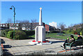
Old Dagenham War Memorial
This is on Dagenham Village Green, a small park opposite the parish church.
Image: © Des Blenkinsopp
Taken: 3 Mar 2025
0.07 miles
9
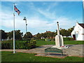
War memorial, Dagenham
A union flag flutters in the breeze at the war memorial in Dagenham.
Image: © Malc McDonald
Taken: 28 Aug 2017
0.07 miles
10
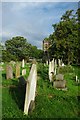
Dagenham Churchyard
The Churchyard of Image is known as Image it is managed as a nature reserve by Dagenham Council and the London Wildlife Trust. For more info see http://www.wildlondon.org.uk/Naturereserves/tabid/91/language/en-GB/Naturereserves/DagenhamParishChurchyard/tabid/129/Default.aspx
Image: © Glyn Baker
Taken: 3 Oct 2010
0.08 miles