IMAGES TAKEN NEAR TO
Broad Street, DAGENHAM, RM10 9HL
Introduction
This page details the photographs taken nearby to Broad Street, RM10 9HL by members of the Geograph project.
The Geograph project started in 2005 with the aim of publishing, organising and preserving representative images for every square kilometre of Great Britain, Ireland and the Isle of Man.

There are currently over 7.5m images from over14,400 individuals and you can help contribute to the project by visiting https://www.geograph.org.uk
Image Map
Images are licensed for reuse under creativecommons.org/licenses/by-sa/2.0
Notes
- Clicking on the map will re-center to the selected point.
- The higher the marker number, the further away the image location is from the centre of the postcode.
Image Listing (27 Images Found)
Images are licensed for reuse under creativecommons.org/licenses/by-sa/2.0
Image
Details
Distance
2
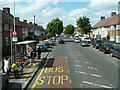
Arnold Road (U) bus stop on Heathway, Dagenham
Served by routes 173, 174, 175 and MB1 towards Becontree Heath or Rush Green.
Image: © Robin Webster
Taken: 25 Jun 2011
0.14 miles
4
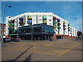
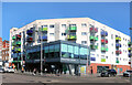
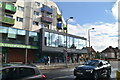
Dagenham Library
Dagenham Library, with flats above, opened in 2010. It is located on the corner of Heathway and Church Elm Lane.
Image: © Malc McDonald
Taken: 28 Aug 2017
0.15 miles
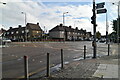
6
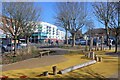
NEW
At the Junction
Hedgemans Road and Dagenham Avenue meet at quite a sharp angle. The triangle at the junction has been made into a small garden or plaza with seats and bits of wood and a sort of Yellow Brick Road through the middle.
A nice place to sit out on a day like this.
Image: © Des Blenkinsopp
Taken: 3 Mar 2025
0.16 miles
7
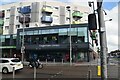
NEW
Dagenham Library
Sharing a town centre site with a colourful apartment block.
Image: © Des Blenkinsopp
Taken: 3 Mar 2025
0.16 miles
9
NEW
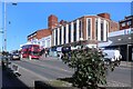
Dagenham Heathway
The main road north-south through here, also known as A1240. Quite short for an A road at under 3 kms, but it has a brief mention here https://www.sabre-roads.org.uk/wiki/index.php?title=A1240
Image: © Des Blenkinsopp
Taken: 3 Mar 2025
0.18 miles