IMAGES TAKEN NEAR TO
Tree Top Mews, Western Avenue, DAGENHAM, RM10 8UY
Introduction
This page details the photographs taken nearby to Tree Top Mews, Western Avenue, RM10 8UY by members of the Geograph project.
The Geograph project started in 2005 with the aim of publishing, organising and preserving representative images for every square kilometre of Great Britain, Ireland and the Isle of Man.

There are currently over 7.5m images from over14,400 individuals and you can help contribute to the project by visiting https://www.geograph.org.uk
Image Map
Images are licensed for reuse under creativecommons.org/licenses/by-sa/2.0
Notes
- Clicking on the map will re-center to the selected point.
- The higher the marker number, the further away the image location is from the centre of the postcode.
Image Listing (26 Images Found)
Images are licensed for reuse under creativecommons.org/licenses/by-sa/2.0
Image
Details
Distance
10
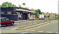
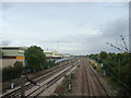
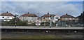
Dagenham East station, exterior
View northward on Rainham Road. Formerly Dagenham station on the ex-Midland (London, Tilbury & Southend) main line to Shoeburyness and London Underground District line to Upminster,it became Dagenham East 12/9/32.
Image: © Ben Brooksbank
Taken: 25 May 1991
0.21 miles