IMAGES TAKEN NEAR TO
Plumtree Close, DAGENHAM, RM10 8UF
Introduction
This page details the photographs taken nearby to Plumtree Close, RM10 8UF by members of the Geograph project.
The Geograph project started in 2005 with the aim of publishing, organising and preserving representative images for every square kilometre of Great Britain, Ireland and the Isle of Man.

There are currently over 7.5m images from over14,400 individuals and you can help contribute to the project by visiting https://www.geograph.org.uk
Image Map
Images are licensed for reuse under creativecommons.org/licenses/by-sa/2.0
Notes
- Clicking on the map will re-center to the selected point.
- The higher the marker number, the further away the image location is from the centre of the postcode.
Image Listing (63 Images Found)
Images are licensed for reuse under creativecommons.org/licenses/by-sa/2.0
Image
Details
Distance
2
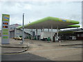
Petrol Station, Rainham Road South, Dagenham
Image: © Stacey Harris
Taken: 2 Sep 2009
0.10 miles
4
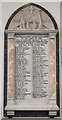
St Peter & St Paul, Church Lane, Dagenham - War Memorial WWI
Image: © John Salmon
Taken: 30 Nov 2017
0.10 miles
5
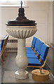
St Peter & St Paul, Church Lane, Dagenham - Font
Image: © John Salmon
Taken: 30 Nov 2017
0.10 miles
6
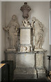
St Peter & St Paul, Church Lane, Dagenham - Monument
Image: © John Salmon
Taken: 30 Nov 2017
0.10 miles
7
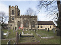
St Peter & St Paul, Church Lane, Dagenham
Image: © John Salmon
Taken: 30 Nov 2017
0.10 miles
8
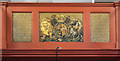
St Peter & St Paul, Church Lane, Dagenham - Royal Arms
Image: © John Salmon
Taken: 30 Nov 2017
0.11 miles
9
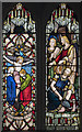
St Peter & St Paul, Church Lane, Dagenham - Stained glass window
Image: © John Salmon
Taken: 30 Nov 2017
0.11 miles
10
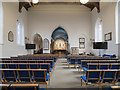
St Peter & St Paul, Church Lane, Dagenham - East end
Image: © John Salmon
Taken: 30 Nov 2017
0.11 miles