IMAGES TAKEN NEAR TO
Ingleby Road, DAGENHAM, RM10 8SA
Introduction
This page details the photographs taken nearby to Ingleby Road, RM10 8SA by members of the Geograph project.
The Geograph project started in 2005 with the aim of publishing, organising and preserving representative images for every square kilometre of Great Britain, Ireland and the Isle of Man.

There are currently over 7.5m images from over14,400 individuals and you can help contribute to the project by visiting https://www.geograph.org.uk
Image Map
Images are licensed for reuse under creativecommons.org/licenses/by-sa/2.0
Notes
- Clicking on the map will re-center to the selected point.
- The higher the marker number, the further away the image location is from the centre of the postcode.
Image Listing (19 Images Found)
Images are licensed for reuse under creativecommons.org/licenses/by-sa/2.0
Image
Details
Distance
1
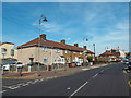
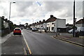
Church Elm Lane, Dagenham
Church Elm lane in Dagenham, in east London's outer suburbs.
Image: © Malc McDonald
Taken: 28 Aug 2017
0.10 miles
2
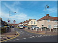
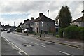
Haresfield Road, Dagenham
Haresfield Road in Dagenham, in east London's outer suburbs.
Image: © Malc McDonald
Taken: 28 Aug 2017
0.10 miles
7
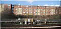
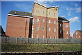
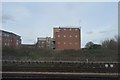
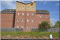
View of Bartletts House, Vicarage Road from Old Dagenham Park
Looking north-northwest.
Image: © Robert Lamb
Taken: 22 Aug 2015
0.19 miles
10
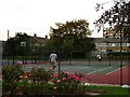
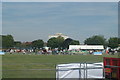
Next Stop Wimbledon?
This tennis court is in Dagenham Old Park a recreation ground at the southeast corner of the Becontree Estate.
Image: © Glyn Baker
Taken: 20 Sep 2005
0.20 miles